
Client Name
City of Marion
Client Type
Location
Cedar Rapids
Project Type
Services Provided
Project Manager

Upgraded Streetscape & Improved Mobility Key to Corridor Plan

Located northeast of Cedar Rapids, the City of Marion has experienced steady growth for more than three decades. This increase in population has had a direct impact on business and industry in the area, as well. Faced with the need to accommodate the increasing multi-modal traffic, Marion city leaders identified the extension of Alburnett Road on the west edge of town as an important capital improvement project for the continued development and growth of the community.
The general alignment for the proposed roadway extension was established by a feasibility study conducted in 2000. The goal was to connect the residential areas on the north side of town to the business and downtown districts at the south end of the city. In 2016, city leaders tasked Snyder & Associates with reviewing the details of the previous alignment, determining if any modifications were needed, and providing a detailed corridor plan.
Our design team planned the extension as a minor arterial street under the Transportation & Circulation Plan adopted by the city in 2010. The basic roadway design and cross-section were created to incorporate the policies and visions of the plan including inviting streetscape features, the accommodation of future growth through vehicular and pedestrian linkages, and a well-landscaped atmosphere to maintain the neighborhood’s unique identity.
Beyond providing a north/south corridor for future traffic growth, another project goal is to reduce traffic cutting through residential neighborhoods, namely on 10th Street between 7th Avenue and Boyson Road. Trail and bike users will also benefit from the plan, as well as emergency vehicles.
Reports, Surveys & Analysis Target Traffic Congestion Reductions & Quality of Life Improvements

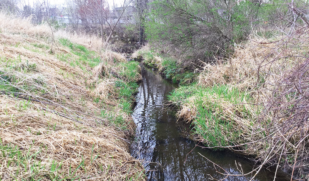
Wetland delineation study area for Alburnett Road Extension project.
The Snyder & Associates team began their analysis of the design concept by performing an initial environmental evaluation of the proposed Alburnett Road extension project area. They were then able to prepare an Environmental Evaluation Report for submission to the city’s engineers. The environmental evaluation report consisted of several studies performed or administered by our team, including:
- Wetland Delineation
- Archaeological Survey & Geomorphological Analysis
- Architectural History Survey
- Geotechnical Engineering Report
As part of the design concept process, Snyder & Associates also completed a Traffic Study for the proposed Alburnett Road extension. The purpose of this study was to determine the capacity, functional geometry, and traffic control needs for the intersections along the project corridor. The study included traffic forecasts, intersection capacity analysis, traffic signal warrant analysis, analysis of possible roundabouts, and recommendations.
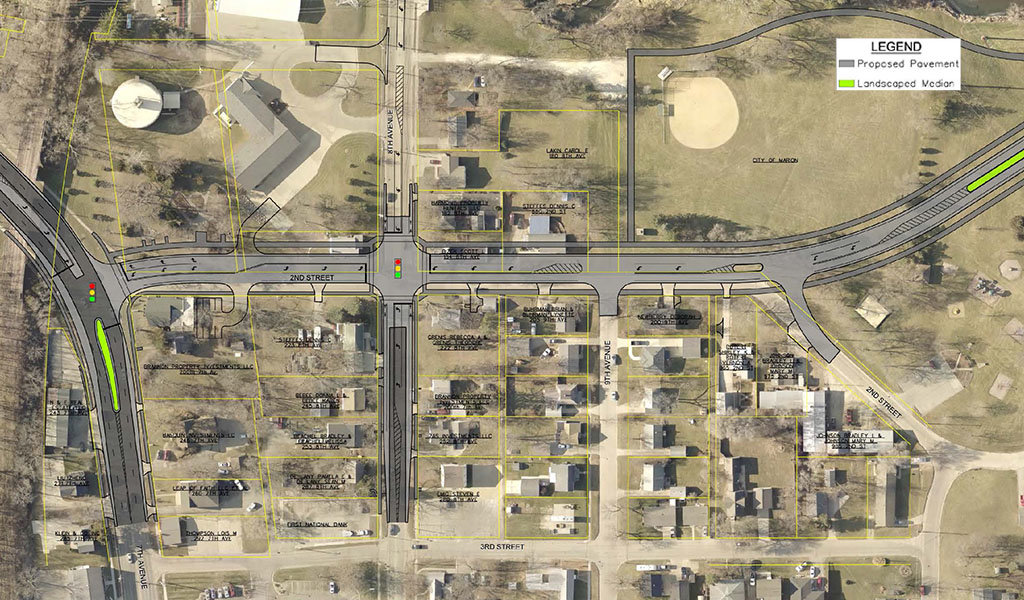
Based on traffic projections and analyses performed, it was determined the Alburnett Road extension should be constructed as a three-lane roadway with one lane in each direction and a continuous center left-turn lane. Dedicated left-turn lanes and traffic signals should also be implemented at select intersections.
Since a portion of the newly extended corridor will run through parks and residential neighborhoods, it was also recommended speed limits be sufficiently controlled for the safety of residents, pedestrians, park visitors, and drivers. A speed limit of 35 mph was deemed appropriate for this minor arterial that will serve commuter traffic traveling to specific destinations, as well as local traffic traveling to and from work, school, and shops.
Multi-Modal Accommodations & Stormwater Management

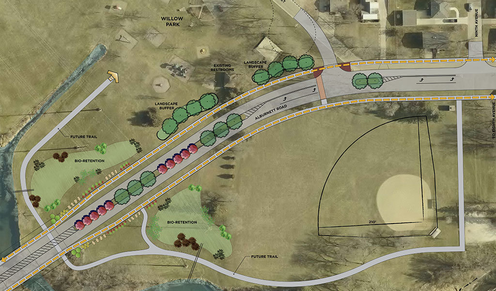
Willow Park was identified as an ideal trailhead location.
As previously mentioned, parks, nature trails, and walkable amenities are located in the region of the Alburnett Road extension project. To accommodate multi-modal transportation and persons of varying abilities, multiple outlets are proposed, including trailhead connections, sidewalk and multi-use side paths, on-street bike lanes, and accessible sidewalk ramps at all intersections.
Due to its proximity to the proposed trail, Willow Park was identified as an ideal trailhead location for the community. The park currently has an existing restroom facility, as well as a small parking lot, both necessary elements for the trailhead. With the proposed Alburnett Road corridor splitting the park into two sections, connections across the roadway would be an important aspect in the revitalization of the park. Landscape buffers are proposed along this portion of the corridor to not only add trees back into the park but to also aid in directing pedestrians to crossing lanes.
Additionally, the streetscape theme was deemed a crucial piece of the extension project. Street trees, green medians, themed street lights, and intersection enhancement features were incorporated into the project design. City leadership emphasized a strong desire for a balance between theming, enhancements, and functionality.
To manage stormwater, a bioretention basin is proposed within Willow Park adjacent to the trail. Bioretention basins capture rainwater and allow it to infiltrate into the soil rather than running into a storm sewer system. These basins would be planted with native grasses, shrubs, and perennials which perform well in these types of environments. Should the basin become full, an overflow channel would direct the extra rainwater into the creek adjacent to the trail and park.
Efficient Roadway Alignment & Cost-Effective Bridge Design
Because the Alburnett Road extension will need to traverse Indian Creek on the north edge of Willow Park, several factors were considered by our team to determine the preferred roadway alignment, including impacts to private property and the environment, avoidance of utilities, public spaces and parks repercussions, future land use opportunities, and overall cost.
Two alignment options were primarily considered for the roadway extension. The main differentiators among the two options were their alignment immediately north of Indian Creek, the location and orientation of the bridge crossing Indian Creek, and how the alignments would bisect Willow Park. The western roadway option was ultimately the recommended solution primarily because of its reduced impact on wetlands and smaller bridge footprint. Additionally, numerous other considerations were examined for this justification, including:
- Avoidance of Interstate Power & Light Company property
- Bowman Meadows future plats already considered in this alignment
- Reduced impact on the forested area
- Less earthwork and soil disturbance
- Better alignment with Indian Creek
- Lower cost
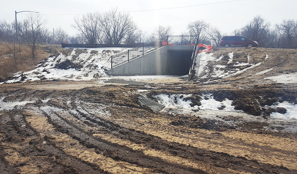
Designed by Snyder & Associates subsidiary, Shuck-Britson, the bridge over Indian Creek created a great opportunity to connect the corridor with its adjacent land uses and also provided an opportunity to enhance a theme for the corridor. Decorative railings on the bridge could be used to introduce an additional metal component, while multiple finishes and colors could be added to proposed site furnishings, such as decorative fencing in the plant beds adjacent to Willow Park and at the intersections along Alburnett Road.

The preferred roadway alignment allowed for the shortest bridge design to traverse Indian Creek.
The bridge superstructure selection considered multiple factors but ultimately recommended the most economical solution while still meeting the physical needs of the specific site. For this application, a three-span, pretensioned, prestressed concrete beam (PPCB) bridge was selected as the preferred superstructure type. The beam details are standardized by the Iowa DOT, providing for ease of manufacture and installation. The durability of this bridge type also ensures very limited maintenance is required, while the overall cost is anticipated to be considerably less than other bridge options.
The Alburnett Road Corridor Extension plan has been embraced by community leaders, with plans to implement portions of the plan in stages as funding opportunities become available. City leaders recognize this vital extension as a critical and necessary capital improvement project for the continued development and growth of the community as it relates to efficient land use, the local economy, safe traffic flow, and a healthy quality of life for their residents.