
Client Name
City of Waukee
Client Type
Location
Ankeny
Project Type

Street Design Guide Provides Road Map for Future Upgrades
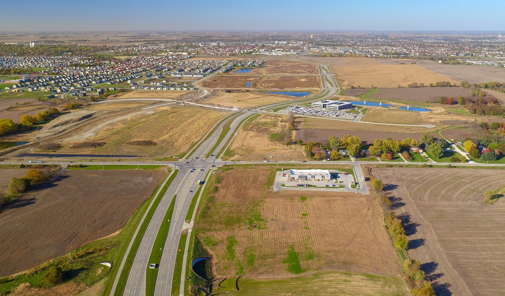
The rapid growth of Waukee over the last three decades has been nothing short of exceptional. As the population grew from fewer than 3,000 residents in 1990 to more than 23,000 today, community leaders quickly adapted to the expanding demographic that has pushed the existing infrastructure to its limits — approving the construction of new roadways and neighborhoods at an unprecedented pace. As the community looks to the future, all signs point to this brisk growth trend continuing.
The transportation planning experts with Snyder & Associates recently completed a Street Design Guide and Major Streets Plan to provide the community with a roadmap for meeting increased demand over the next 20 years. In its basic form, the Street Design Guide is a reference manual that provides community leaders with a working definition and description of the different levels of street classifications and corresponding examples of each in Waukee. Graphic representations are also included in the guide to provide a visual representation of the typical cross-section of each of the indicated street designations. The guide provides clear alternatives for developers to implement, and likely impacts from, new site development proposals while reducing the need for costly traffic impact studies.

Black and white street design plans
The Street Design Guide was developed to complement the public engagement efforts held during the creation of Waukee’s Comprehensive Plan, Imagine Waukee 2040. The comprehensive plan included a series of open houses to engage citizens on the future needs of the city, including on future transportation needs and goals. Additionally, the City of Waukee Fire and Police Departments were engaged to gain insight on primary response routes and operations to help inform typical roadway cross-section development. The input was also beneficial to identify the appropriate balance of slowing traffic while maintaining a high level of emergency response for the various street types.
Utilizing the feedback received about the transportation network, the Street Design Guide identifies where in the existing street network traffic calming elements can be added to provide safer connections for users of alternative modes of transportation. This drives toward the goal of creating attractive transportation corridors that reflect the vision and enhance the marketability of the Waukee community.
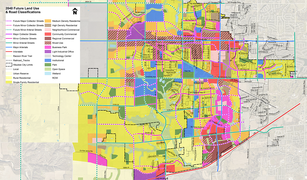
The Major Streets Plan portion provides a detailed map of the city that identifies future land use and roadway classifications. The map is an easy reference that indicates where new roadways will be located as the city expands. It also distinguishes commercial, residential, industrial, and mixed-use areas, among others.
Properly Defined Street Classifications Guide Planning Process

Waukee street design poster
The street classifications designated for Waukee include major and minor arterials, major and minor collectors, and local streets. The major arterial streets serve as primary centers of activity in urbanized areas and are used for high-traffic volume corridors to carry most of the traffic entering and leaving the area, as well as trips that bypass the city center. Additionally, they handle significant intra-area travel, such as between central business districts and outlying residential areas. In Waukee, Hickman Road and Grand Prairie Parkway are prime examples of major arterials.
Minor arterial streets connect with and augment the major arterial streets system by increasing access to private land, neighborhoods, and streets of a lower classification level while maintaining limits on access points. The spacing of minor arterials varies from ⅛ to ½ mile in urban areas and as much as two to three miles on suburban fringes. University Avenue and Westown Parkway represent two of the minor arterials in Waukee.
The collector street system provides both land access and traffic circulation within residential neighborhoods, commercial, and industrial areas. Unlike the arterial systems, however, collector streets penetrate residential neighborhoods, channeling traffic to and from the arterial network. Major collector streets, like NE Dartmoor Drive and SE Brick Drive, connect arterial streets with minor collectors, while also collecting traffic from local streets, residential, and commercial areas. Through-traffic movement is prioritized over direct land access on major collectors. Minor collectors, such as SE Florence Drive, SE Pleasant View Drive, and NE Boston Parkway, provide movement between major collectors, residential, commercial, and local streets, while also providing access to abutting properties. Through-movement of traffic and direct land access are weighed evenly when considering access points to minor collector streets.
As outlined in the Major Streets Plan, local streets allow direct access to abutting land and provide connections to higher-order street systems. They provide the lowest level of vehicular mobility and should deliberately discourage major through traffic movements. Examples of local streets in Waukee include the majority of residential streets throughout the community.
Traffic Calming Measures Appropriate for Several Street Types
Included in the Street Design Guide are specific traffic calming measures for several of the specific street types in Waukee. Traffic calming devices are used to encourage motorists to adhere to posted speed limits to create a safer roadway environment for all motorists, bicyclists, and pedestrians. Collector and local streets have several traffic calming strategies that are appropriate for the identified classification. Some of these measures can be applied retroactively to existing streets, while others should be part of a street redesign or initial construction.
Calming measures are most commonly advisable for the collector and local streets given lower travel speeds of motorists and the emphasis placed on neighborhood penetration. Listed below are several measures appropriate for these street classifications.
- Chokers
- Corner Extensions
- Median Islands
- Roundabouts
- Mini Roundabouts
- Speed Tables/Raised Crossings
- Crosswalks
- On-Street Parking
Finally, this guide includes certain design criteria, access spacing guidelines for the identified categories of streets, and a reference chart for design options when considering new intersections. These design recommendations have been developed with input from the City of Waukee Public Works, Development and Emergency Response staff and are based on criteria found in the Iowa Statewide Urban Design and Specifications Manual (SUDAS).
The City Public Works and Development Services Department began using the new Street Design Guide immediately to confirm and inform new roadway designs for both public capital projects, as well as roadway improvements that are associated with residential and commercial developments throughout Waukee. The city is also currently implementing traffic calming elements identified in the guide on two established Minor Collector streets to address speed concerns along the corridors. “Before” speed and volume data have been collected along both streets and “After” data will be collected for comparison and effectiveness of the selected treatments.