Relocation Patterns Highlight Continued City Expansion
Since the early days of the Industrial Revolution, rural Americans have steadily moved to urban areas, often searching for better jobs. Modern relocation patterns continue to reflect that trend — but in addition to diversified career opportunities, people are also seeking expanded schooling opportunities for children, more entertainment options, more accessible access to quality healthcare, and an overall change in scenery. For urban areas, this continued influx of new residents comes with many challenges for cities looking for ways to become more attractive to new businesses, easier to navigate for visitors, and livable for residents.
For rural communities experiencing an outward migration of people, the focus shifts from maintaining community balance to recreating an identity that entices others to move there. Increasingly, these cities are required to place greater emphasis on improved roadway safety and the ability to offer a variety of transportation options.
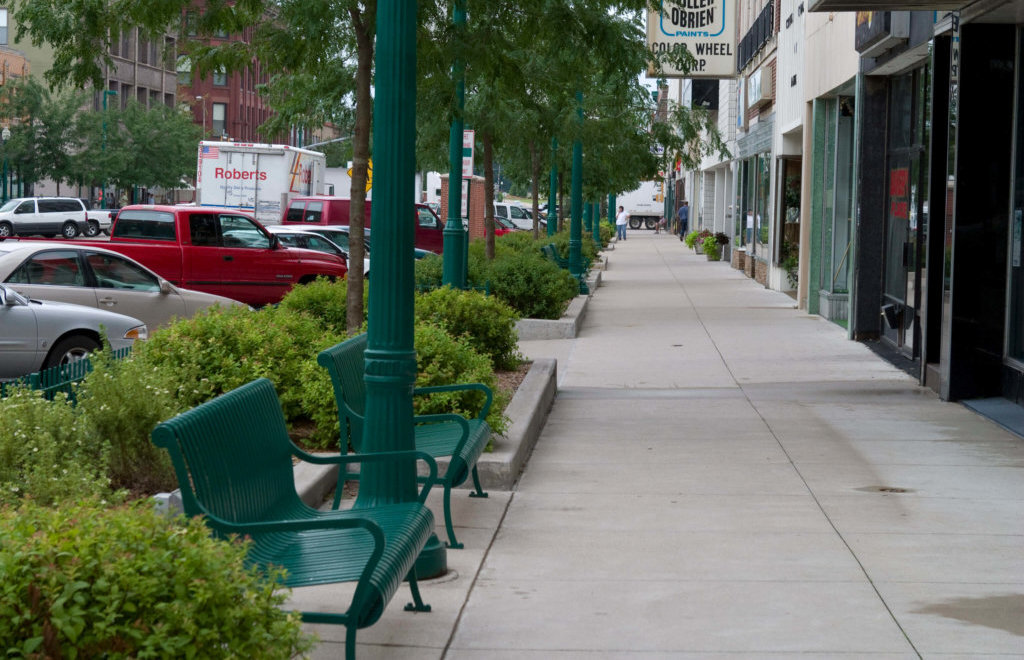
However, nearly every community is faced with the reality of roadway corridors that place a substantial priority on automobile traffic. These corridors are sometimes characterized by aging roadways with multiple lanes, businesses separated from the street by large parking lots, unsightly utility poles and overhead wires, a noticeable lack of trees and vegetation, sidewalks that are too narrow or in poor condition — if they exist at all, and in some cases, dangerous intersections or at-grade railroad crossings that lead to fatal crashes.
Adverse Impacts Addressed by Professional Engineering Services

Transformative streetscape corridors provide safe accommodations for all users.
Every day, the seasoned transportation planners and engineers at Snyder & Associates work to improve these corridors and upgrade their multimodal capabilities. Our team knows first-hand that corridors displaying these adverse conditions will ultimately have a negative impact on the people who live, work, and travel along them.
At the same time, we realize these roadways are essential for local and regional trips and often serve as significant connectors. With this knowledge in mind, our approach to corridor transformation considers the roadway and the entire community surrounding the corridor. We develop a “complete streets” strategy considering how we can impact land use and improve safety through intelligent, comprehensive planning initiatives. We compare adjacent land uses against the corridor’s role within the community to discern any potential enhancements needed to foster revitalization and growth.
Additionally, our solid understanding of funding opportunities allows our team to assist communities in procuring the funding they need to bring their projects to life. From the quintessential small-town “main street” to large metropolitan geographic areas, the extensive range of our experience means that we can scale a solution to meet the size and complexity of any request. Explore how our transformative corridor approach has impacted the Iowa communities of Clinton, Des Moines, and Fort Dodge.
Transformative Corridor Solutions Scaled to Address Community Needs
Clinton Streetscape Establishes Placemaking Environment
Extending through the oldest part of downtown Clinton and ending at the Mississippi River, our team developed a corridor plan that creates an inviting and pedestrian-friendly space along a three-block section of 5th Avenue South. This project focused on creating a streetscape that welcomed shoppers and recreational users with bike-centric amenities and easy pedestrian navigation among the shops and businesses along the corridor.
As a central element of this design, our team took advantage of an approximately two-foot elevation change between the street and business levels by incorporating steps and ADA-compliant ramps that strengthen multimodal accessibility and provide separation from the roadway and on-street parking areas. Trees, accent planting beds, decorative water fountains, gateway features, and comfortable seating areas were also carefully integrated to enhance the pedestrian experience and create a comfortable sense of place.
Along the project corridor, mid-block pedestrian crossing areas anchored by four large brick columns were included with the project. These significant vertical elements help calm traffic and separate pedestrian zones for improved safety. They also matched the mix of concrete and brick sidewalks, decorative street lighting, and safety rails that provide the finishing touch to this streetscape revitalization. This small-scale project has dramatically impacted the Clinton community by transforming this once-stagnant downtown corridor into a proper destination location.
Decorative lighting and adequate seating helped make the Clinton streetscape a comfortable destination.
Funding Efforts Drive Broadway Avenue Reconstruction
Just under two hundred miles to the west, another transformative corridor project is currently in the planning and design phase. Broadway Avenue on Des Moines’ north side is a busy, mixed-use corridor that carries industrial, commuter, and local traffic from 2nd Avenue in Des Moines to Hubbell Avenue on the outskirts of Altoona. This narrow roadway has numerous shortcomings, including the lack of a sidewalk network and several at-grade railroad crossings that have been the site of countless crashes.
To address traffic flow concerns, our plan calls for widening the entire corridor for a three-lane roadway with a shared center turn lane. This reconstruction effort will incorporate a new railroad underpass at one crossing location and upgraded signals at two others. Roundabouts at two intersections and a new fiber optic-connected traffic signal system will be implemented along the corridor to coordinate traffic flow better and improve the roadway’s reliability.
The plan also includes a side path along the corridor that will intersect with the Chichaqua Valley Trail and connect with the Gay Lea Wilson Trail to the east, creating an entirely new regional trail loop for users. A future phase of this trail connection project will ultimately extend west to the Neal Smith Trail along the Des Moines River, linking over 100 miles of regional trail network. This critical multimodal consideration had long been lacking along this busy corridor.
To mitigate the additional stormwater runoff created by the increased pavement area, several stormwater bioretention basins have been strategically included in the plan. This $50 million+ reconstruction project is made possible through our team’s ability to align federal and state funding programs with the necessary corridor improvements.
Our team took the lead in writing the grant application for the $25 million Better Utilizing Investments to Leverage Development (BUILD) Grant program funds. Our team also wrote the grant applications for eight additional state and local funding sources, including Revitalize Iowa’s Sound Economy (RISE) funding and other safety-related funds. The Snyder & Associates professionals can help navigate this often-cumbersome funding process, write grant applications, and administer the appropriate documentation to get any project across the finish line.
City-Wide Master Planning Transforms Multiple Fort Dodge Corridors
Over the last two decades, the Snyder & Associates team has worked with city leaders in Fort Dodge to reimagine their community and rejuvenate aging infrastructure. This effort has involved transforming corridors on a city-wide scale — tying entire sections of the town together to take advantage of the community’s assets. Four prominent projects include the Cross-Town Connector, the East Region Improvements, the Des Moines River Districts Improvements, and the Northwest River District Revitalization Plan. These projects and several others across the city highlight the impact of corridor transformations to improve transportation networks and social cohesion.
Cross-Town Connector
The Cross-Town Connector project focused on the realignment of Iowa Highway 926 through downtown Fort Dodge. This effort included the acquisition of blighted and abandoned downtown properties to “right-size” the core business district. Additionally, a continuous corridor was created to connect the west and east sides of town, allowing the downtown business district to serve the entire community better.
The project included quality-of-life enhancements such as a civic plaza, bike lanes connected to the regional trail system, streetscape amenities, and specialty pavements. To streamline the operations of the local street network, two roundabout intersections were designed and built, and 13 traffic signals were removed. The overhead utility infrastructure was buried to improve the aesthetic appeal and provide better pedestrian accommodation.
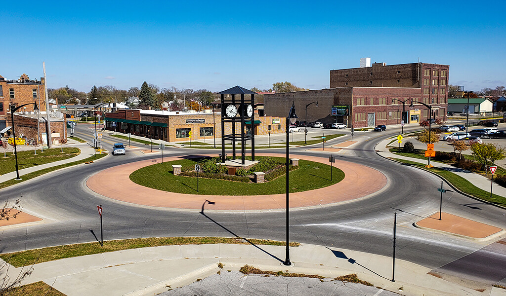
The Cross-Town Connector’s two roundabouts provide a safe and seamless intersection option.
East Region Improvements
Located in the eastern part of Fort Dodge, the Crossroads Mall area is a hub for commercial shopping and dining. The mall has gradually seen an exodus of businesses, causing a reduction in investment from the private and public sectors. Challenges also included a collector street network that was inefficient and encountered frequent flooding due to an undersized storm conveyance system. Our team worked with the city to upgrade the street network with new pavements, improved traffic signal systems, and implementation of a road diet to accommodate turning traffic more efficiently and safely.
The storm sewer was updated, and regional stormwater detention facilities were constructed strategically to address the increase in runoff from the heavily developed surrounding areas. The final phase of construction of these improvements is set to commence. As these “basic” improvements are made, it better positions the city for redeveloping a dilapidated retail area into a regional draw comprised of recreation, shopping, dining, and living spaces. The city is actively working to revitalize the eastern part of Fort Dodge to further enhance the quality of life for its citizens.
Des Moines River Districts
The Des Moines River District comprises three main areas: Little Dam District, Central River District, and Hydro-Electric Park District. The Snyder & Associates team has been leading a group of consultants to rejuvenate the western portions of the city. Two high-hazard dams — Little Dam and Hydro-Electric Dam — have been removed, thus creating opportunities for enhanced recreation in and along the Des Moines River. Revitalization planning for each dam site is underway, with in-stream fishing and white-water amenities at the Little Dam site being planned for 2022 construction.
The Central River District, located mid-way between the two dam sites, is a unique area within Fort Dodge, providing a critical connection between the historic downtown and the Des Moines River. Although the river is no longer a significant commercial or industrial transportation route, it can serve a more critical role as a destination site rich in recreational opportunities and natural beauty. By investing in improvements to the river district and providing enhanced connections to the downtown area, the city can recapture the importance of this natural system and encourage visitors and residents to use and experience this region.
Our team’s planning efforts identified four unique focus areas for transforming this Central River District location: the riverfront park and development area, a light industrial section, Central Avenue, and the village. Specific redevelopment options and amenities were recommended for each project area to support private entertainment and recreation businesses and accommodate existing industrial services, offices, and commercial spaces within the district. Central Avenue acts as the spine connecting the downtown to the riverfront.
This area primarily presents opportunities to enhance the pedestrian, bicycle, and vehicle connection between the historic downtown and the riverfront. The village area was identified for the potential to offer mixed-use commercial and residential redevelopment opportunities, with an emphasis on business incubation and multi-family housing. Furthermore, city leaders are working with Webster County officials to develop a new Nature Center within the Central River District planning area that will catalyze development, spurring additional recreational amenities to be constructed along the riverfront.
Northwest River District
Bordered by the Des Moines River to the east and Lizard Creek to the south, the Northwest River District was also ripe for a revitalization effort. Although this neighborhood lies near some of the larger agriculture-based businesses in the region, the area has experienced little growth since the 1980s. It offers very little in the form of neighborhood services. In the past, the presence of the two encompassing waterways was viewed as a barrier that divides the Northwest River District from the rest of Fort Dodge. The only connection point is through the single bridge crossing on Hawkeye Avenue. The revitalization effort aims to capitalize on the proximity of the Des Moines River and US Highway 169 to create recreational and business opportunities to reestablish the district as the proud western gateway to Fort Dodge.
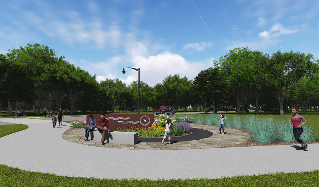
The Northwest River District Plan calls for plaza areas, public spaces, and trail connections.
Primary considerations include the reconstruction of the 3rd Avenue NW and Hawkeye Avenue Corridor, which bisects the district. Additionally, gateway enhancements to establish a neighborhood theme would promote a sense of pride for residents, while the Lizard Creek area can be used to offer more recreation opportunities. Connecting the isolated North Neighborhood to the main corridor is crucial for encouraging local investment.
This would be accomplished by extending the sidewalk and trail loops at Hawkeye Bridge and Hydro-Electric Park. The corridor planning phase included redevelopment opportunities within the central part of the Northwest River District to provide enhanced commercial, vertical mixed-use, and residential development opportunities. Each proposed land use was supported by a market analysis completed by our team to substantiate the reality of return on investment. The city has assembled parcels along the corridor to open opportunities aligning with the plan.
Transforming Corridors — & Communities
From small-town streetscapes to city-wide initiatives, well-planned corridor projects have the potential to bring immense transformational change to previously troublesome areas. Focusing on strategies such as reimagining land use, fostering multimodal initiatives, eliminating food deserts, removing blight, and adding mixed-use development can reshape and renew long-forgotten urban areas.
Our team’s holistic and comprehensive approach considers how a corridor contributes to the overall benefit of the surrounding community. We thoroughly examine potential safety improvements, transportation options, environmental sustainability opportunities, and specific modifications that would link residents to the corridor and improve connections to jobs and other parts of the community. Contact the Snyder & Associates team to find out what our professionals can do to help transform your corridors — and your community.