Changing Climate Patterns Create Uncertainty for Communities
Does it feel like every spring goes down as the wettest on record? Does it seem that you’re always hearing about another 100-year flood event? It’s not your imagination — weather patterns are rapidly shifting due to the impact of global climate change. The amount of stormwater flooding is increasing. Spring floods are becoming more severe. Images of flood-damaged transportation infrastructure, commercial properties, and residential neighborhoods are all-to-familiar scenes in the daily news.
These unprecedented and transformative events have communities across the country asking themselves, “what can we do to better protect ourselves?” According to Mark Land, P.E., CFM, Vice President of Snyder & Associates, building community resilience to flooding and other weather-related events begins with a comprehensive approach to planning and communication. “Communities often reach out for help after horrific flooding has occurred, but planning in advance is possible,” he shares. “Every day, we help communities understand the impacts that ever-increasing rainfalls will have and help them improve their resiliency before damage occurs.”
Understanding Your Communities Floodplains & Flood Risk
“The first step of mitigating flood risk is to have a good understanding of your floodplain,” shares Land. “Once you know how stormwater flows and what’s at risk, you can identify improvements and plan for them.” Floodplains are low-lying areas that are more likely to flood when runoff volume exceeds the capacity of rivers, lakes, and streams. The closer you are to a floodplain, the higher your risk for flooding.
Preserving floodplains, or developing them in ways that can endure floodings, such as implementing green infrastructure or flood-tolerant parks, can prevent unnecessary risk to people and help avoid costly damage to property and local infrastructure. Floodplain maps are available through the Federal Emergency Management Agency (FEMA) but additional modeling information is often helpful for community planning and flood mitigation efforts.
Having confidence in stormwater conveyance systems can only be achieved by examining and simulating their performance under various conditions. That’s why our team utilizes advanced modeling software to help identify and optimize proposed drainage

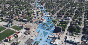
Advanced floodplain mapping helps communities visualize impacts and engineers provide right-sized solutions.
system improvements. One of the most common methods used by the Snyder & Associates team is hydrologic and hydraulic modeling, which provides a way to learn more about potential flood impacts and what’s at risk. “Hydrologic modeling is a tool we use to help determine runoff volume,” explains Land. “Hydraulic modeling shows us how high water will flow and the path it may take.”
“When addressing issues of resilience, we want to know how a community can bounce back? How long will water be standing in neighborhoods? If we implement a specific solution, how quickly can we get the water down? Stormwater modeling helps answer those questions,” states Land.
These systems were put to the test when the City of Des Moines reached out requesting watershed improvements near Closes Creek. To produce true-to-life flood elevations within streets and between homes, our team added local stormwater facilities such as storm sewers, reservoirs, culverts, as well as overland and bypass flow routes to the model. In the end, the information these models provide helps engineers and community leaders gain a deeper understanding of potential flood impacts and what’s potentially at risk to guide informed community decision-making.
Reducing Flood Potential through Stormwater Infrastructure Improvements

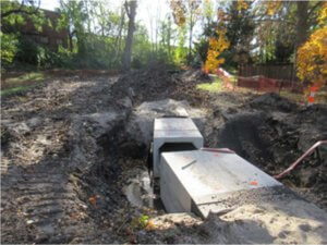
Updating infrastructure like this shallow storm sewer box culvert helps communities create resiliency against flooding and reduce overall flood potential.
Armed with a thorough knowledge of runoff volume and flow, our team then typically investigates opportunities to improve stormwater management infrastructure. This often begins with an analysis of all stormwater facilities and structures currently in place.
According to U.S. Environmental Protection Agency (EPA), most of the existing water infrastructure was designed based on past hydrologic records without consideration for the notable changes in rainfall intensity and variability driven by climate change. That means that many of our current water and wastewater utility systems were not built for extreme rainfall or heat stresses, and without upgrades, it’s fair to expect more frequent failures.
Comparing how stormwater flows and how the infrastructure is currently performing helps identify where there are shortfalls now and where others might occur in the future. Systems most at risk are those with combined wastewater and stormwater pipes because sudden deluges could cause overflow, putting public health at risk. New infrastructure is calibrated to meet current and future demands. With larger pipes, upgraded technology, and increased capacity, communities are better prepared to face the continuing changes in our environment.
Comprehensive Planning Key Strategy in Reducing Flood Risk
While helping communities understand the floodplain impacts of new land development or evaluating the efficacy of current infrastructure are both key pieces to becoming flood
resilient, comprehensive planning is perhaps even more crucial for effective flood prevention. “We’re experiencing increasingly unpredictable weather patterns, and a comprehensive plan is necessary to help communities respond and adapt accordingly,” says Land.
Comprehensive plans are regularly used to establish a vision for future land uses and to promote a more resilient community. Directing development away from current and future growth areas that are susceptible to flood impacts promotes greater community resilience and can alleviate the impacts of floodwaters. Similarly, these plans can be used to pinpoint valuable environments that lessen flood and erosion risks if left in their natural state.
In addition to directing development away from flood-prone areas, comprehensive plans can also incorporate more widespread goals and objectives that are complementary to flood reduction, such as promoting green infrastructure and personal stormwater reduction practices. Though some of these objectives may seem individually insignificant, if combined with proactive planning, they can make a sizeable impact.
Proactive planning that sets strategic priorities allows a community to target limited recovery resources before the next disaster. When disaster-related funds are available, this forethought allows communities to immediately begin allocations to areas that will maximize stormwater management, fulfill community objectives, and support community resilience.
Despite more data being gathered every year, effective planning involves more than what we already know. Planning based solely on what’s occurred in the past doesn’t properly prepare communities for what’s ahead. “It’s about more than the data we have. To help communities brace for the impact of changing weather patterns, we need to think about what science is predicting. By doing that, we’re able to help communities empower themselves to think sustainably and plan with resilience in mind,” states Land.
Alternative Strategies for Managing Flood-Prone Areas

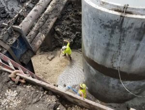
As communities expand, larger infrastructure is required to meet stormwater demands. By upsizing their infrastructure, communities are better equipping their systems for the future.
Floodplain mapping, infrastructure studies, and comprehensive planning efforts are critical tools for pinpointing the areas that could benefit from more focused flood prevention measures. As one example, they could help determine if an area’s drainage system is insufficient or too costly to upgrade. In this case, there are a variety of solutions that could improve stormwater management and strengthen community flood resilience, including:
Property Buyouts
In areas with high flood risk, a community may want to explore strategic buyouts of affected properties to help relieve the burden on residents. This option is often less expensive than infrastructure improvements, and it provides opportunities for additional stormwater detention basins or public space improvements.
Green Infrastructure
Permeable pavers, rain gardens, green roofs, live walls, and other green infrastructure components help promote stormwater management and infiltration in urban environments.
Native Landscapes
In place of traditional grass and shrub landscaping, native plants are a smart alternative. The use of native plants helps promote stormwater infiltration due to robust root systems that create space within the ground. Additional benefits of native landscapes include improved water quality, biodiversity, livability, and reduced maintenance.
Flood Control & Infrastructure Improvements
Improving stormwater conveyance and storage capacity continues to provide the best solution to address rising floodwaters. A combination of stormwater wetlands and upsized culverts often create a dramatic shift in flood protection for the neighborhoods involved.
Preventing Future Flooding through Multi-Faceted Planning Efforts
The combination of a comprehensive flood plan, advanced floodplain mapping, and updated stormwater infrastructure won’t stop the increasing climate events, like heavy rainfall, but they can certainly lessen the impacts. Understanding what options are best suited for your community can be the real challenge.
As we look towards the future, our team is fully aware that growing communities have concerns. While addressing the increase in runoff that results from land development, communities must also ensure that infrastructure is designed, built, and maintained to handle the uncertainty and intensity of the changing climate. When it comes to helping a community determine the right proactive solutions for their unique circumstances, we take a comprehensive approach that accounts for future forecasts because the actions we take today are essential to prepare us for what’s ahead.
