Proactive Engineering Designs for Increased Roadway Safety
With the constant reminders in our daily newsfeed, it’s difficult not to notice the increasing number of fatalities and injuries occurring on our nation’s roadways. Factors such as speeding, aggressive driving, distracted driving, drunk driving, and drowsy driving often play a role in this dire circumstance. Inexperienced drivers and inappropriate driving habits in the case of weather conditions can also have a contributing influence. Further, transportation experts have found that vehicle interactions at high speeds and intersections are two of the leading causes of driver and pedestrian fatalities. It’s also true, however, that many roadway traffic deaths and injuries are partly caused by structural deficiencies in roadway and intersection design, meaning these types of crashes can be minimized or avoided by establishing the right combination of design measures. In the past, the high cost associated with safer roadway designs has tempered implementation progress. However, as technology advances and more funding opportunities become available through sources like the Bipartisan Infrastructure Law (BIL), new infrastructure is quickly becoming a cost-effective solution for cities, counties, and other municipalities.
Five Strategies for Safer Roadway Infrastructure
Working with various local governments, Snyder & Associates engineers and transportation experts have been at the forefront of designing and implementing roadway infrastructure that establishes safer and more efficient networks for drivers and pedestrians. From practical design guidelines to tangible infrastructure suggestions, this snapshot of design strategies provides insight into five techniques popular with our professionals.
1. Access Management (AM)
While not a direct engineering solution, Access Management (AM) is a critical design component for encouraging healthy and safe growth. Roadways serve two primary purposes: mobility and access. While mobility deals with the efficient movement of people and goods, access allows those people and goods to reach specific destinations and properties along those roadways. Access Management strategies are designed to maximize mobility by managing access to adjacent properties. Managing existing and newly constructed corridors has long been a significant concern in many states. As sections of rural land on the outskirts of expanding communities are developed, there’s pressure to add features such as commercial driveways, at-grade public road intersections, and traffic signals to arterial highway routes that should primarily serve high-speed traffic.

Planning for access management in advance of expansion creates a safer traffic environment.
These added features can potentially diminish the speed and traffic capacity of these roadways and cause significant safety issues. This is where access management comes into play. Properly implementing access management principles balances the competing needs of traffic mobility and safe access to adjacent properties and supports future land development along a corridor. Â The traffic professionals with Snyder & Associates know the critical impacts of designing roadway networks while adhering to proper access management guidelines.
2. Pedestrian-Focused Accommodations
Pedestrians face several safety issues when crossing or interacting with roadway traffic. These risks increase exponentially when roadways have multiple lanes and support heavy traffic. Pedestrian-friendly measures should be viewed as a toolbox of strategies available to slow traffic, reduce dangerous crossings, and create a safer environment for not only pedestrians and cyclists but also drivers. Raised medians and pedestrian islands are one design strategy that can provide a safer way for pedestrians and cyclists to cross busy roadways.
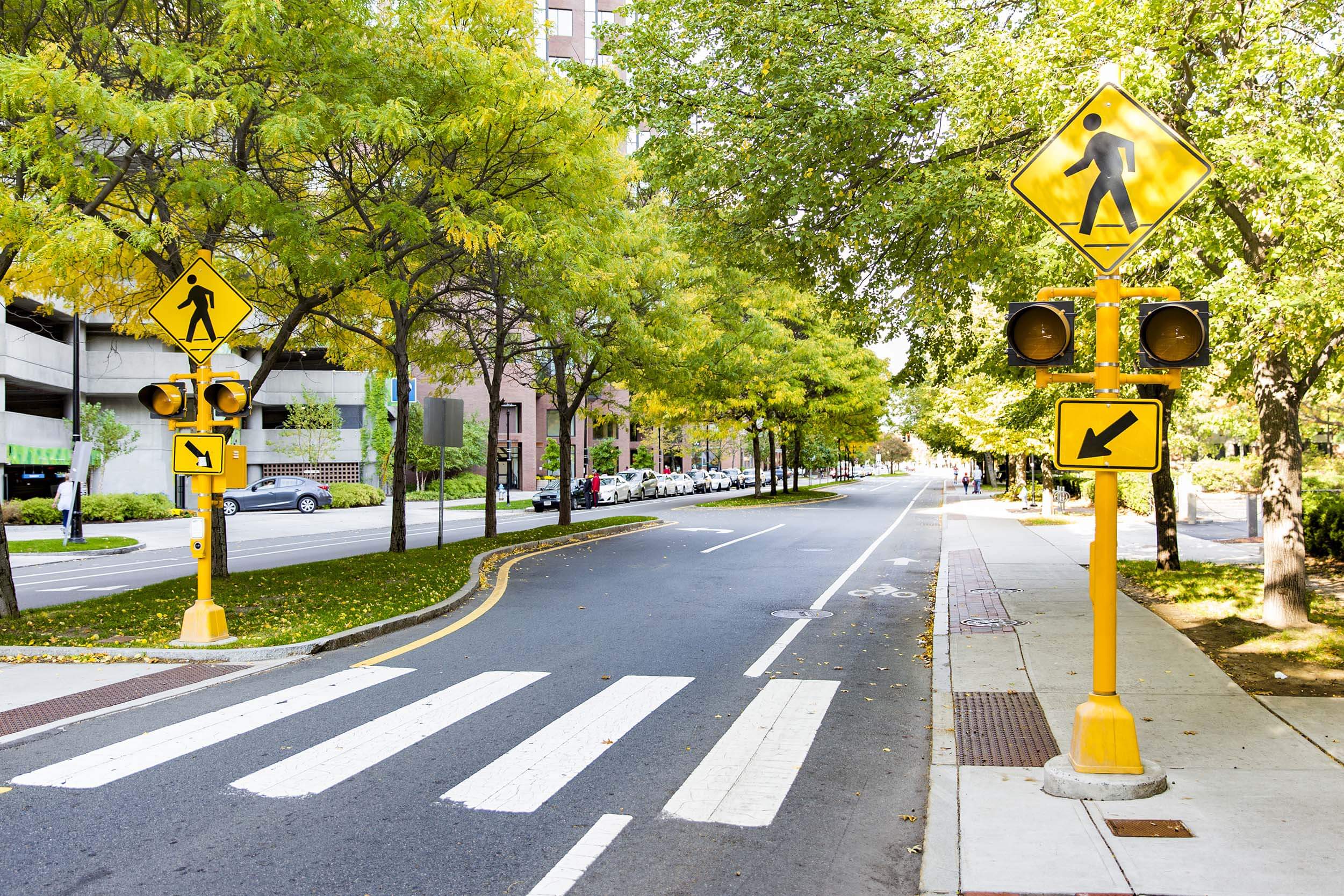
Proper signaling and raised medians reduce crashes involving pedestrians.
This allows users to cross halfway and then reevaluate oncoming traffic from the safety of a raised area before proceeding. They also work to keep the opposing lanes of travel separated. Narrowed roadway lanes and curb bump-outs are two more strategies for calming traffic and providing safer pedestrian access. Popular at busy intersections, these roadway tools are increasingly common near high foot traffic locations, like shopping districts and sports stadium venues. While crashes involving pedestrians account for an increasing percentage of overall traffic injuries and fatalities, many of these incidents are preventable with the proper engineering strategies.
3. Road Diets
In the early days of road construction, roadway projects typically focused on system and capacity expansion. When the traffic volume of a two-lane road exceeded what it could accommodate, more lanes were added. This was a standard solution to address congestion issues, so four-lane roads became the norm across the country. However, it turns out that more lanes are not always the best solution for every corridor.

A “road diet” refers to removing vehicle travel lanes while maintaining the same width. The most common form of a road diet (lane reduction or lane reconfiguration) converts a four-lane, undivided road into a two-lane road with a center, two-way left-turn lane. Road diets change how roadway space is allocated by simply moving the striping. By giving left-turning traffic its own space and through traffic its own space, you only need three lanes, not four. The extra space created by a road diet can be used for parking spots, bike lanes, and other complete street improvements that encourage active transportation and support the local economy. This low-cost strategy is an efficient way to enhance safety and improve access along a corridor.
4. Roundabouts
While initially more popular in European nations, roundabouts have become increasingly popular in the United States over the last two decades. Modern roundabouts are circular intersections that move traffic counterclockwise around a center island, creating a more efficient and safer environment. Designed for lower-speed driving with all traffic moving in the same direction, roundabouts have yield signs at each entry point, giving vehicles in the roundabout the right-of-way. Compared to a traditional intersection with traffic signals, roundabouts reduce the conflict points from 32 to only 8, drastically lowering the chances of vehicle crashes.
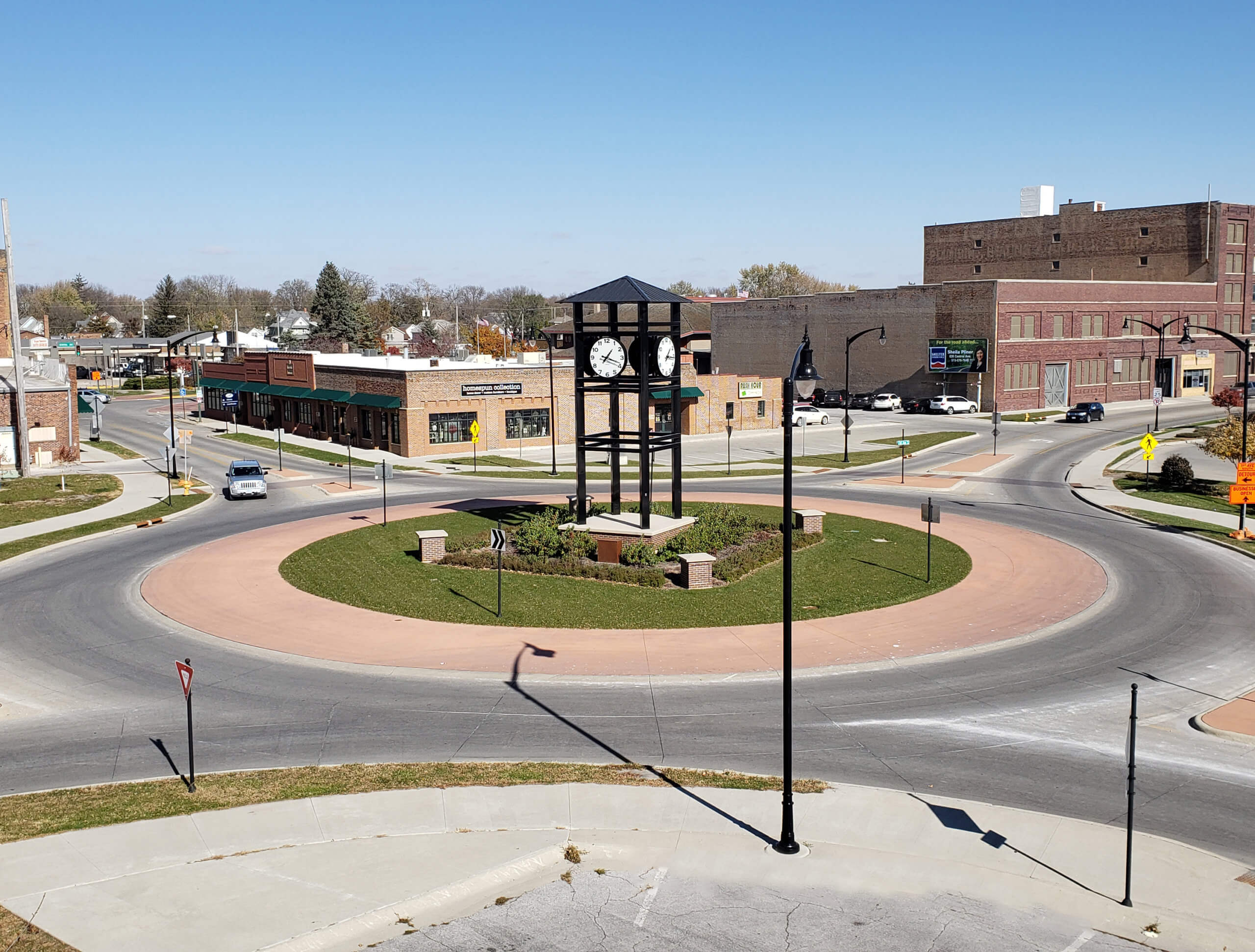
As part of the Cross-Town Connector in Fort Dodge, roundabouts were strategically placed to improve traffic flow and reduce crashes.
While initial expenses are generally higher than a standard four-way intersection, roundabouts have a much longer expected service life. In addition to being safer, roundabouts also help reduce carbon emissions and fuel consumption that commonly occur with time spent sitting at red lights. When deciding between a roundabout and a traffic-controlled option, each location’s traffic volume and size are crucial factors that must be considered.
5. Diverging Diamond Interchange
A fresh concept in interchange design, known as a Diverging Diamond Interchange (DDI) or Double Crossover Diamond Interchange, takes traffic safety and efficiency to a new level. In a traditional diamond interchange, approximately 26 conflict points can lead to traffic crashes. DDIs have just 14 conflict points. Fewer conflict points mean fewer vehicle opportunities to collide, resulting in a safer, more efficient traffic flow.
In a DDI, traffic is shifted from the right side of the road to the left side of the road at each intersection between the interchange ramps and the side road. This means left-turning traffic doesn’t cross paths with oncoming traffic, reducing the chance of a collision. Once left turn intersections are cleared, traffic is returned to the road’s right side.
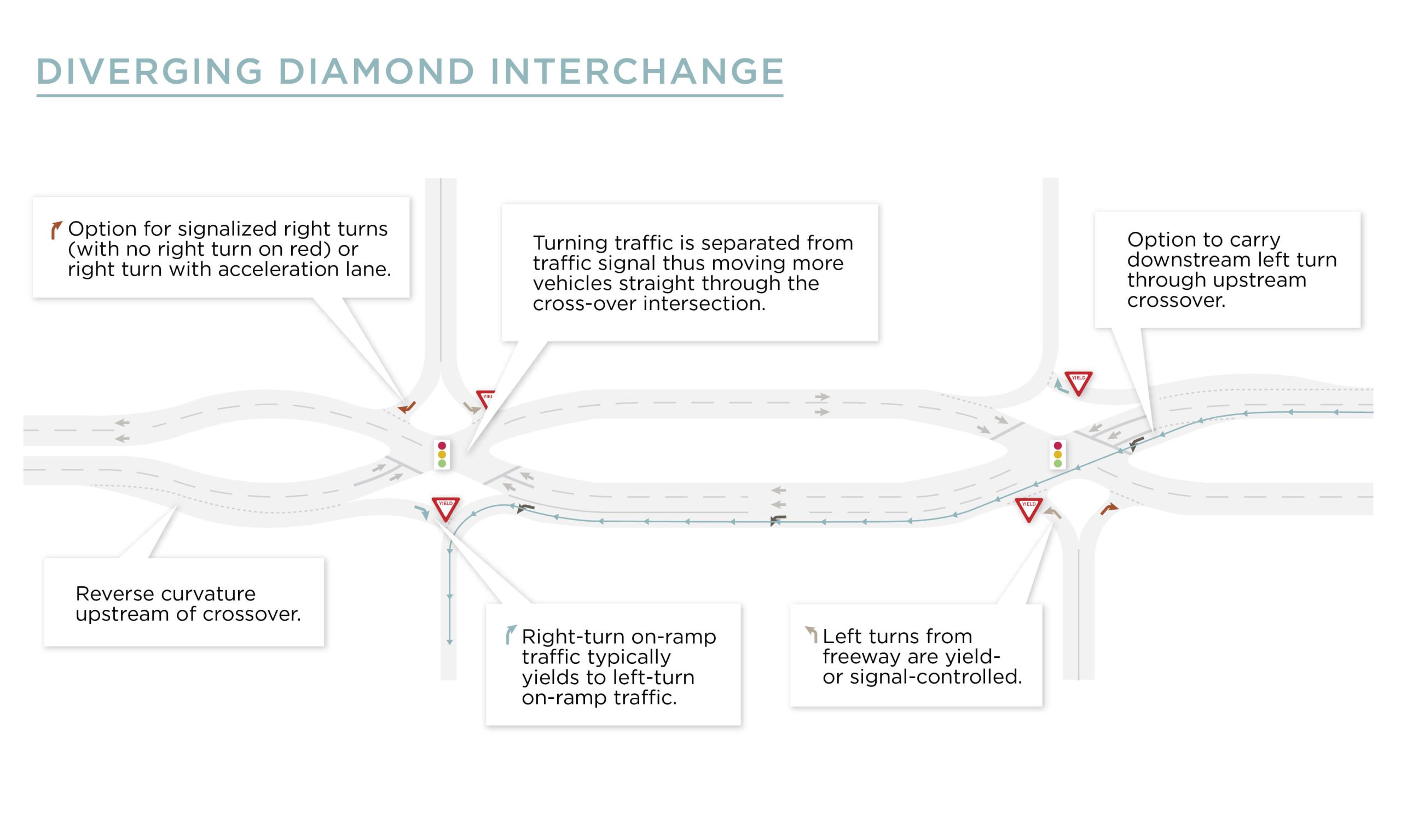
Like the concern with roundabouts, DDIs utilize an unfamiliar traffic pattern that can create apprehension and fear for some drivers. Driving on the left side of the road may feel counterintuitive and even hazardous. DDIs provide numerous safety, operational, and cost benefits over traditional diamond intersection designs, including reduced collision potential and increased safety by reducing the number of times vehicles cross paths. Many strategies can be used to improve the nation’s roadways for greater driver and pedestrian safety. This brief look at design strategies provides insight into five techniques popular with our transportation experts. Utilizing all resources, our professionals stand ready to help guide communities and maximize the funding options available to implement roadway design techniques that prioritize safety and efficiency.