The Significance of Managing Floodplains
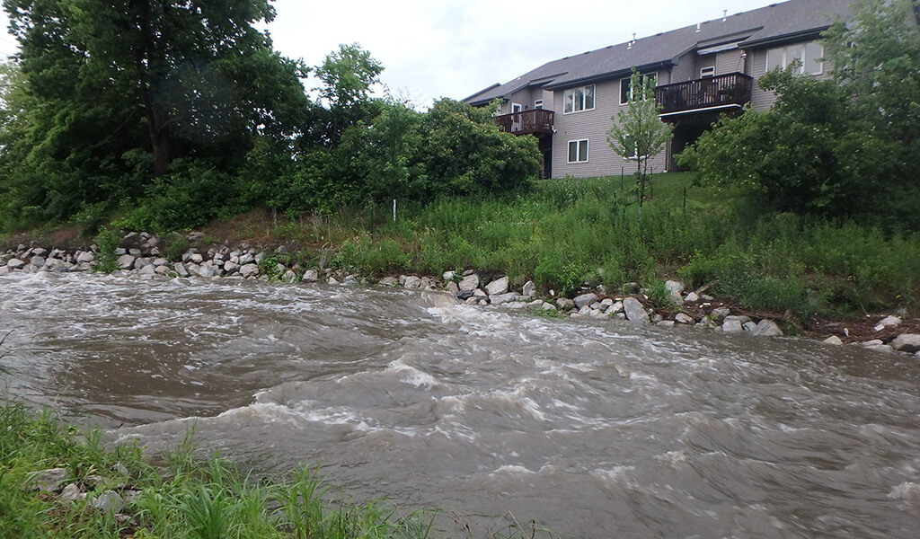
A massive storm causes a 100-year flood. The term “100-year” simplifies a flood that has just a 1% chance of occurring in a single year. Mistakenly, many assume that experiencing such a flood means they are safe for the next 99 years. The probability of a 100-year flood remains constant at 1% each year. Without preparation, these rainfall events can be devastating to a community. However, effective stormwater management and planning can mitigate the potential damage. In times of significant flooding, the flat areas adjacent to a river’s edges, referred to as the floodplain, play a crucial role. They act as a natural space that slows down and spreads dangerous floodwaters.
This process prevents the waters from inundating communities along the riverbanks, thereby preventing harm to people and property. When properly handled, floodplains offer a wide array of advantages to both human society and the environment. These benefits range from shielding against floods to preserving water quality and providing habitats for wildlife. To ensure that floodplains remain resilient in the long term and that nearby developments are well-protected, the Snyder & Associates team dedicates their efforts to identifying and resolving potential concerns during the early stages of project development.
Creating Functional Designs in a Floodplain
Snyder & Associates studied the Fourmile Creek Watershed to update the floodplain model, replacing outdated FEMA maps.
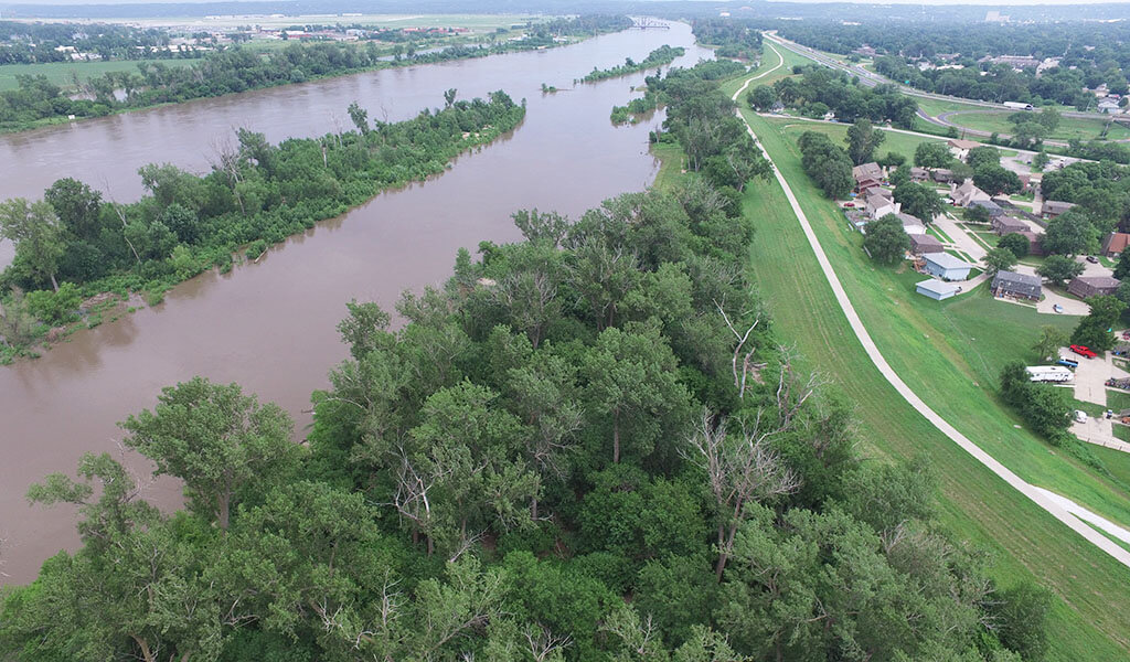
Rivers and streams are continuously meandering and changing paths. Setting aside room for this movement and the passage of significant flood events is a community’s best protection against flood damage. It is one of the most substantial routes to maintain an adequate floodplain. However, these areas are often in high demand for development. Assessing flood risk and planning for functional floodplains requires a comprehensive understanding of the factors contributing to high water events. Working with professionals like our environmental scientists and stormwater engineers can give businesses and communities the expertise to reduce susceptibility to future flood damage.
When dealing with projects in floodplains, the initial focus is on the project’s location in the floodway. Although development within a floodway is feasible, it is intricate due to the requirement of not increasing water surface elevation during a 100-year storm event (Base Flood Elevation or BFE). This entails navigating a time-consuming and expensive process with FEMA. Understanding the development’s position relative to historical flood data and modeling guides us in assessing risk and determining the necessary permits.
For any floodplain development, any structure (including its basement) must be elevated at least one foot above the BFE – a standard that often necessitates more significant elevation in certain jurisdictions. This guideline is established to minimize flood-related damage and lower flood insurance premiums. Furthermore, adhering to building codes mandates elevating mechanical and electrical systems to or above the BFE, and any construction materials used below the BFE must be flood damage resistant. While compliance with building codes ensures the safety of occupants, it might fall short in securing a facility’s sustained functionality post-flood. When devising plans for a facility located in a flood-prone area, our focus is on creating a design that fulfills permitting and code requirements while ensuring long-term viability in that location.
Performance-Based Design Approach
Historically, building codes took a prescriptive approach, limiting options for compliance and hindering innovation. In contrast, our specialists adopt a performance-based design approach. This method evaluates how the entire building system, encompassing both landscaping and the actual structure, is expected to perform under conditions associated with potential hazards. From the outset of design discussions, we guide project decisions to ensure a resilient design aligned with City, State, and Federal codes. In certain regions, the flood risk is deemed too significant for development. Community green spaces, localized detention basins, and stormwater wetlands emerge as favorable alternatives. These spaces are purposefully designed to withstand flood events with minimal damage during substantial storms.
Our team demonstrated this concept on the east side of Des Moines through the Easton Boulevard Detention Basin. This previously flood-prone area near Leetown Creekway was transformed into a stormwater detention basin with added park amenities like recreation trails, landscaping, benches, and lighting surrounding the basin. This basin now safeguards against up to 100-year storm events, boasting a maximum storage capacity of approximately 94.5 acre-feet while serving as a community greenspace for nearby neighborhoods. Collaborating with floodplain assessment and planning experts allows communities to envision the potential within these seemingly challenging landscapes. While planning marks a crucial starting point, the subsequent development phase grapples with the intricate task of satisfying federal and local permitting regulations.
The Role of Public Policy in Floodplain Development
Council Bluffs has initiated ten projects to recertify its entire levee system before the 2023 FEMA assessment. This is to protect residents from flooding and potentially higher insurance costs.
The Federal Emergency Management Agency’s (FEMA) National Flood Insurance Program primarily determines how floodplains are developed. FEMA maintains an ongoing collection of flood maps that undergo updates to account for climate changes, like increased rainfall and intensified storms, as well as improved modeling methods and recent developments. These flood maps assist mortgage lenders in determining insurance necessities and empower communities to devise approaches for minimizing their risk.
However, while FEMA establishes a foundational framework for floodplain management, local governing bodies may impose extra or more stringent regulations regarding floodplain development. Numerous states and communities throughout the country are enhancing flood mitigation cost-effectiveness by using regulations to steer development away from high-risk zones. In tandem, they are creating policies that optimize the returns on modest upfront government investments. Stakeholder engagement is critical in a community’s policy decisions for flood prevention and mitigation efforts.
By engaging stakeholders, organizations can increase awareness of flood risks, facilitate collaboration and coordination, tap into local knowledge and expertise, implement effective strategies, and improve communication with the local community. By working together, stakeholders can help communities make informed decisions when adding development in the floodplain.
Harnessing the Power of the Natural Environment
Floodplains constitute a vital component of robust river systems that have been altered through levees, dikes, and other construction. While development often becomes necessary, it does not inherently have to harm the surrounding ecosystems. Our team’s commitment to identifying and addressing floodplain issues at the outset of projects guarantees a harmonious coexistence between communities and floodplains. We recognize that the vitality of a floodplain extends beyond disaster prevention — it encompasses fostering a flourishing, equilibrium-rich ecosystem that enhances the well-being of everyone. Contact our professionals today and let us help you explore ways to devise intelligent designs within your floodplain areas.