Drones Advance Land Surveying Capabilities
Aerial drone imagery of U.S. 151 near Anamosa complemented traditional survey methods.
Survey technology is soaring to new heights with the addition of unmanned aerial vehicles (UAV) or drones, as more commonly known. When fitted with GPS technology and a high-resolution camera, these drones are often called unmanned aerial systems (UAS). These remotely flown aircraft, equipped with a full package of software and hardware, offer a new approach to construction progress, observation, and monitoring, including photos, videos, and traffic studies.
In the land survey field, drones add an entirely new dimension with their ability to provide aerial photogrammetry, 3D site modeling, photo comparisons, and aerial video. They’ve even shown their value in determining stockpile, basin area/volumes, and infrastructure inspections. With a forward-looking approach to land survey and civil engineering design, the Snyder & Associates team is excited to provide their clients with a deeper bench of solutions using the eyes in the sky their drones offer. “All of the service offerings we provide will benefit from this technology and the data a UAV provides,” shares Snyder & Associates Surveyor Ted Jansen. ” We can swap different cameras, thermal imaging units, and other components to provide different project efficiencies for our clients.”
Determining Which Project Types Benefit from a Drone Survey
Every survey project begins with a discussion of the overall project needs to determine how the survey fits into the big picture and what survey methods are applicable. Site accessibility, constraints, and project limits are essential for selecting an appropriate aerial flight. Here are some common questions that help determine if an aerial survey would be beneficial.

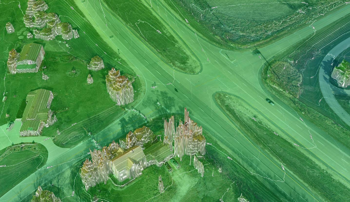
An ortho-mosaic image of U.S. 151 was used to create a 3D model of the project site.
- What surrounds the project site?
- What are the ground cover conditions?
- What deliverables are needed, and when are they required?
Every project is different, and not all sites are accessible for aerial services. Realistic expectations need to be made, taking timing and weather into account. If the ground can’t be seen from the sky, the accuracy of an aerial survey is diminished. Project sites within five miles of certain airports require FAA authorization before an aerial flight can occur, which typically takes two days and two weeks to receive approval. Evaluating the wide range of factors that influence site accessibility and your project needs and goals helps maximize the use of resources and project funds.
Operating a Drone for Land Survey
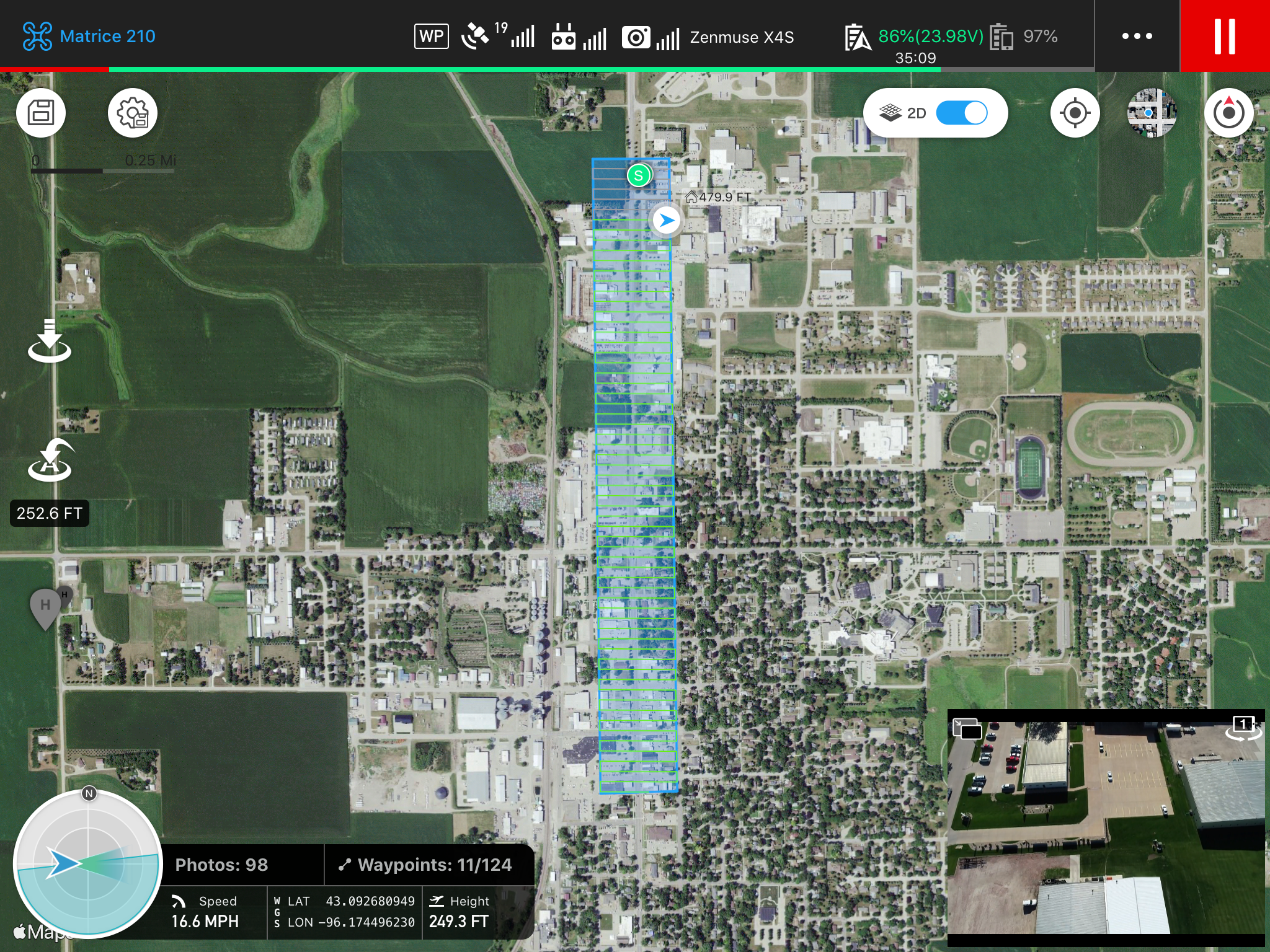
This is a visual depiction of an autonomous flight program during work on Iowa U.S. 75 near Sioux Center. The 3D modeling of the project corridor was instrumental in providing citizens with a first-hand view of the proposed project details before construction began.
The UAV can be flown manually or fully autonomous with manual backup. A fully autonomous flight follows a predetermined plan designed by the flight team. During an autonomous flight, data is collected and processed using cloud-based processing software that transmits to a tablet. An FAA Part 107 certified UAS pilot monitors the flight from the ground to ensure safe UAV operation. The site’s existing topographic features determine the altitude of the flight, and the altitude determines the image resolution.
As altitude increases, resolution deteriorates, diminishing image clarity and the accuracy of the surface data. On the other hand, higher altitudes decrease survey flight time and data file size, decreasing costs and allowing a more efficient file size. The maximum altitude that a commercial UAS is typically allowed to fly is 400 feet above ground level (AGL). While it’s usually a breeze to fly a UAV and gather data, more goes on behind the scenes to make that data usable. A UAV provides a point cloud with georeferenced coordinates and elevations to create a surface at many locations. Design Technicians analyze and process the UAV’s data to produce the desired deliverables.
Best Projects for Drone Use
Drones can assist with a variety of civil engineering projects. However, there are specific instances where a drone may be recommended:
- Safety — rough terrain, heights, and other circumstances that pose safety risks to survey and engineering staff
- Level of Detail — UAVs can be flown at low altitudes to gather high-resolution data that rivals traditional survey methods
- Project Planning, Progress, & Closeout — UAVs can help capture existing site data, which is valuable in assisting with land planning and phasing. In addition, as the project progresses, a UAV can be used to track project milestones and provide aerial images of the result.
Can Drone Surveying Replace a Traditional Survey?
A UAS will not eliminate the need for on-site surveyors or traditional survey methods. Instead, it’s designed to enhance current survey methods by offering greater detail and better coverage of the information gathered. Ted and his colleagues have determined that utilizing the UAS increases the usable data available for design while reducing time in the field and increasing the team’s efficiency. Regarding accuracy, the horizontal and vertical errors of the UAS cannot be less than the site control points and the method by which these control points are obtained. Control point placement on the project site, logging, and processes will determine the overall accuracy of the flight survey. Boundary surveys, underground utility surveys, bathymetric surveys, and the need to verify and check aerial survey data will always be required and remain a common practice.
Using UAS Technology on Your Next Project
Snyder & Associates provides comprehensive services and utilizes various cutting-edge technologies to gather data efficiently and accurately. Whether you have environmental disturbance or site access concerns or would just like to get a bird’ s-eye view of site topography, UAS can be beneficial. Contact Eric Miller to learn more about Snyder & Associates’ UAS program and explore opportunities for UAS technology on your next project.