
Planning for Success, Revitalizing the Fort Dodge Community
While Fort Dodge had experienced a steady decline in population for many years, city leaders have slowed the decline, and the community and region are recently rebounding. By implementing innovative initiatives and building partnerships, new businesses are being attracted to the area, creating fresh opportunities for existing and new residents. Despite facing setbacks, the consulting teams revitalizing the Fort Dodge community recognize the unlimited growth opportunities by focusing on the region’s strengths. We understand the importance of the task at hand, believe in the leadership of this great community, and are honored to lead a strong team of consulting professionals to implement a wide array of strategies to turn the tide for the region.
Listen as our Transportation Business Unit Leader, Wade Greiman, P.E., and Fort Dodge’s Chief Development Officer, Chad Schaeffer, P.E., discuss the planning and implementation processes of bringing the community’s downtown and river districts back to life!
Webinar Agenda
- Background (00:18)
- Re-Envision 2030 Comprehensive Plan (2:40)
- Water Trails & Corridor Plan (4:19)
- Northwest River District Master Plan (5:20)
- Bike & Ped Mobility (7:34)
- Central River District Master Plan (9:19)
- Downtown Streetscape Master Plan (11:01)
- Implementation Strategies (12:58)
- Dam Removals & Stream Mitigation Bank (13:24)
- Lizard Creek Mountain Bike Trail (15:47)
- Northwest River District Phase 1 (17:03)
- Little Dam Park & In-Stream (19:06)
- Webster County Conservation Center (20:45)
- Central River District North 1st Street (21:58)
- Central River District Front Porch & In-Stream (22:44)
- Skate Park (23:25)
- Downtown Alleyway Improvements (24:33)
- Hydro Electric Park and In-Stream Features (25:32)
Background (0:18)
Wade Greiman
Well, good morning, and thank you for the opportunity to present. My name is Wade Greiman. I work with Snyder & Associates as the firm’s Transportation Business Unit Leader. I have been with the firm my entire career, and with me today is Chad Schaeffer, the Chief Development Officer with the City of Fort Dodge. Anytime you get into a situation where a community is struggling, and Fort Dodge has been struggling for several decades or had been struggling, you need to take an internal look at who you are and some of the issues that you’re facing. Fort Dodge has been considered a rural hub for retail, jobs, recreation, and a population base approximately 80% bigger than they are today. Their downtown was built for a population base of about three times bigger than what they are today. If you have ever driven downtown, there are a lot of skyscrapers that were constructed in the early 1900s. They are large seven, eight-story brick structures, and most of those stories on the upper floors are vacant.
So, they have been facing a downward trend since the seventies, eighties, and nineties, when they lost about 3,000 jobs in the region. When Hormel closed, Electrolux eventually closed in Webster City. As a result, people started to migrate away from the town, searching for work. So, you have that downward trend, and what are you left with? You still have the infrastructure that you need to maintain and take care of, and you do not necessarily have the economic resources to do that. So, we take a look at what it is that we need to do as a community to turn that trend around. We did some internal searching through the city’s leadership and Webster County’s leadership, and we were fortunate enough to be a part of that exercise with them on several initiatives from the planning perspective and the engineering side.
The Des Moines River was probably identified as the greatest asset that the city has. It is a natural environment, and you can do many great things within there, but when people move away, areas that get neglected are sometimes the natural areas. We talked about the downtown struggling with a lot of the infrastructure that does not necessarily have the resources to take care of it. Then the East mall called the Crossroads Mall or was, has since been demolished we started to see this attrition of businesses leaving as well. So anytime you have these areas within the city that are becoming dilapidated, it becomes a struggle to keep on top of
Re-Envision 2030 Comprehensive Plan (2:40)
One of the things the city identified to do out of the gate is to update some of the plans they had in place. The work done before was not poor, it was just outdated, so the city took on a new initiative of re-upping its comprehensive plan. They hired Houseal Lavigne, and we were a sub-consultant to them to be the local rep related to the infrastructure improvements that would be bolted into this study Houseal Lavigne they are out of Chicago. They embarked upon a very aggressive public involvement process that was critically important to gather feedback from the public so that we could help to identify what those specific deficiencies were, what they were perceived to be, and then how to address those appropriately. Many of the things they were struggling with were crime, the quality-of-life initiatives in place that were starting to be neglected, and dilapidated neighborhoods. The thing that we bolded here and highlighted was the riverfront. We realized that the river was still the greatest asset that the city had, so that was the focus of today’s presentation on how we are going to revitalize that riverfront and make that something to be proud of for the region.
As part of the comprehensive study, it was important to understand that to balance the growth with the importance of the environmental issues that we are facing in the city as well as the constraints that we were dealt with and to tie those together to make sure that we are not just impacting the environmental side of things with growth but making sure that we are trying them together to be enhanced and building upon each other. With that public engagement process, it was very evident that that was one of the most important things to do to carry forward as we went through the implementation plan.
Water Trails & Corridor Plan (4:19)
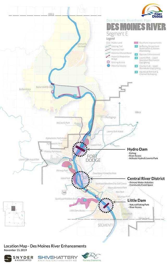
Proposed improvements along the Des Moines River adjacent to Fort Dodge.
As part of that and concurrently with the comp plan, Houseal Lavigne was hired by Fort Dodge with a partnership with Webster County to take a look at the Des Moines River along with Lizard Creek and establish a water trails network. Major focus areas were not only to bring people closer to and utilize the river itself but also to improve the safety within the river.
There were two dam structures within the City of Fort Dodge proper. The hydroelectric dam is located in the Northwest part of the city, and the little dam is downstream in the Southwest part. Both dam locations had taken people’s lives in the river at one point or another. They would go over the spillway in a canoe or kayak, get caught in a tumbler downstream, and lose their lives. We felt that it was important to identify the fact that that was happening, that people still wanted to use the river, so what could we do to make that river a safer environment for people to use?
Northwest River District Master Plan (5:20)
Also, regarding what the land uses adjacent to the river, we identified a couple of different districts within the city.
The Northwest River District was one of them. This part of town is isolated from the rest of the city by Lizard Creek on the South and Des Moines River on the East. It is one of the three main arteries that feed into Des Moines, into Fort Dodge from the West, Highway 1-69, and has a population base of 25,000 people. Most of the 80% greater than that are being served from the retail and shopping perspective within the city come from the North and the West. So, this neighborhood was quickly identified within this master plan to serve a strong role for the population base that is being served from outside the city limits with the strained economic engine that the City of Fort Dodge has. Serving a population base that much bigger but still maintaining the infrastructure outside funding was critically important to bring that into the fold, update some of the streets, update the trail network, and bring people into the neighborhood to shop and recreate.
With Lizard Creek on the South and Des Moines River on the East, that confluence is also a focal point for several different things. There is a mountain bike park there now. There is also the river trails component, where people are kayaking down Lizard Creek and migrating into the Des Moines River. So, it is starting to turn itself around. A lot of dilapidated homes in these neighborhoods. As you can imagine, this area is struggling from an economic perspective. A lot of the neighborhoods are comprised of LMI folks. So, revitalizing that neighborhood through the infrastructure improvements and planning and incentive packages that the City of Fort Dodge has initiated is becoming a very strong thing to help to turn this neighborhood around.
One of the things that we identified within that study is to bring some sense of pride to the neighborhood, and just to the east of it is a grain silo, and it was very unsightly. So, the City of Fort Dodge hired a guy; where was he from? Australia, and he painted this by hand. That has become the talk of the region. Many people are talking about this quite a bit, and that’s become the focal point of this neighborhood. People are proud of it. It is a nice little gateway coming in from the East.
Bike & Ped Mobility (7:34)
One of the other initiatives that we discussed in the comp plan of importance was the importance of bike and ped mobility, not just from the commuter perspective but also from the recreational perspective. And there are a lot of regional trails within the area that are not connected together within Webster County. This was a partnership between the city and the county, and we looked at Webster County as a whole and identified some shortcomings that could be accentuated with new improvements to connect some disconnected communities to the greater trail network.
It also has some focus as it relates to the riverfront being the greatest asset that the city has. We felt it was important to continue that effort with the trail network along both banks. The cities of Gallery and Dayton are also embarking upon constructing a trail loop within each community and then ultimately a trail will connect the two communities together and then Northeast of Fort Dodge up to Badger. A trail will be constructed here in the next year or two to connect that community to Fort Dodge as well. But it is not necessarily just the connections. It is also identifying the correct application for mobility to be accommodated within each corridor, whether it’s a share or whether it’s a side path or a cycle. The track committee, Mindy Moore, formerly of our office, led this effort, and she identified several different avenues to provide this type of mobility within the city.
They did a phenomenal job. There was a heavy public engagement component to this too. I think it is important to reiterate that in every planning aspect that we have had, we have had a lot of great feedback from the community it is not to say that they were starving for providing feedback, but they are a very active group and a very informed group too. So that was very rewarding to be a part of it.
Central River District Master Plan (9:19)
The two districts along the river that I talked about the first one being Northwest River District and the second is the Central River District. We talked a little bit about downtown. This is straight West of downtown, adjacent to the river. There is a connection to the downtown, called Central Avenue, which you can see right here. That feeds down into the river bottom there from Central Avenue downtown. It is probably 50-100 feet higher than the river in the Central River District.
So, there are some topographic challenges related to this connection, but we are focused primarily on identifying what that area could be. This is the site where the Hormel plant was back in the eighties. It became a dumping ground for the public. So, there was a lot of, I would say, brownfield cleanup that was necessary before we could transform this into what it will be. The city and the county conservation had agreed on a partnership to revitalize this area, and the county conservation is constructing a conservation center on the northern third of this site. That is the area that is on the top. That is where the conservation centers focused. And then in the middle third, just adjacent to Central Avenue, that is where the front porch will be. That will be more of a natural recreational park-type facility for the city.
And then the South third is being reserved for a private development of some sort, whether that would be a hotel or a restaurant with a rooftop bar. Just imagine the possibilities to bring people down into the riverfront Ragbrai was there a couple of years ago. This was a large gathering space with much green space today. So, the city’s embarking on a plan to bring more people in more of an active role essentially.
Downtown Streetscape Master Plan (11:01)

Several zones were created to designate improvement areas in the Central River District.
I talked a little bit about the planning efforts within the downtown itself. We were fortunate to be hired by Fort Dodge Main Street to take a look at a streetscape master plan for the downtown. There is a streetscape plan that was implemented 25 years ago, and a lot has happened in the downtown since then. With that streetscape and the limited resources that the cities had, some of that has experienced almost their entire life cycle, their spots where a lot of TLC is needed.
So Main Street Fort Dodge brought some funding to it and hired us to do a master plan, and we took a look at not only just the streets but the modal uses within the downtown. I want to say probably 10 years ago. We ended up removing a dozen traffic signals within the downtown, which helps accommodate pedestrian and bicycle mobility. It also helped with traffic flow if we converted signals to four-way stops, and it works much better. But the signals 25 years ago were probably well justified because there was more population-based going through the downtown itself. So, it is part of that revitalization in bringing the pedestrians and bicyclists into the downtown to use those shops and restaurants and so forth, so that helps. We went through a public engagement process with this, and then on the left side, you will see 741 participants were involved with this.
That is a pretty good number. A lot of data to sift through to figure out what the priorities were, but you can see the four-star to 2.1-star ratings on the right side of the categories. The 2.1, the thing that was realized by the public was that there was no two-way bicycle traffic accommodated within the downtown itself, and that was the low marking there, but for the most part, the downtown has the capacity to handle, accommodate, and accentuate the pedestrian and bicycle mobility to help to revitalize that. So that was probably the biggest takeaway for that study. I will turn it over to Chad to talk about the implementation strategy stemming from all these plans.
Implementation Strategies (12:58)
Chad Schaeffer
Thanks, Wade. Before I get started, just a little bit about myself. I have been working in government for the last 20 years and with the City of Fort Dodge for the last 15. They hired me in 2008 to be the city engineer. I get to oversee the engineering department, but then I also get to work with our economic development and our planning teams. I am kind of the liaison back and forth between our groups, internal to the city and then external with our Greater Fort Dodge Growth Alliance.
Dam Removals & Stream Mitigation Bank (13:24)
As Wade said, we had two dams in the city, both very dangerous, just a bad situation. One was a hydroelectric dam. We had not produced power since 1974. It was just sitting there obsolete and a hazard to our water trail system throughout the county. So, we decided that now is the time to do that removal, and we can do that with the planning efforts with Snyder & Associates to help establish a mitigation bank to help fund that removal. With that whole process, to be able to put together that mitigation bank, we now have 80,000 credits to sell. So, as you are doing projects throughout the Des Moines River Basin, we would love for you to buy some credits from us to help pay for our dam removal project, but it also helps your process, you do not have to go do that mitigation work on your project. We have already done substantial work by doing the dam removal, by doing stream bank protection, erosion protection, and all those types of things. So, it is a great project for us, and hopefully, it helps you guys put your projects together as well.
You can see in the picture what is left of the hydroelectric dam. There were five gates that were operational. Again, no improvements had been made to that thing forever. So, we had guys going out onto the top of the dam trying to operate those gates. Very dangerous 1930s equipment types of things, and so we decided that was not a good idea, but that is what is left from a historical standpoint. We wanted to save the platform for the powerhouse, and we wanted to save one of the gates just so that we could show the history of what that site looked like. Then in the future, we will come back, put a platform on top of where the powerhouse used to be, maybe a cantilever platform over top of the gates, and create a little viewing space where those gates used to be.
And you can see a little dam down here in the bottom right that was not a hydroelectric dam, and it was about a six-foot high dam that pulled water off of the river into a power plant and use that for cooling water. Again, that power plant went away 40 or 50 years ago, and it had no use. We were able to do the removal there and create a cool space, and you will see some pictures here coming up. This is that little dam site. We are doing that coordination with Snyder & Associates through the wintertime. They just broke it into pieces, and then the guy would change the buckets and pull that material back onto the shore as we went from both sides.
Lizard Creek Mountain Bike Trail (15:37)
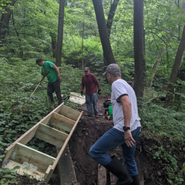
Volunteers work on building a mountain bike course on a city-owned parcel.
Wade talked about our trail system; this is just one of the components. This is a cool project within the city. Completely volunteer-led. They started work on this mountain bike park before any of us knew what was going on. It was city property against underutilized. It is perfect for a mountain bike park. And right next to Lizard Creek, there are some serious elevation changes. These guys went out there and started building that thing.
Last year they held their first competition and here in June and they are going to hold another one. We have had next to no assistance as a part of that project other than signage and trying to keep the mountain bikers off the railroad. That is just one component of our trail system. Wade had shown the map of our trail system. We have over 40 miles of paved trail throughout Fort Dodge and Webster County and with connections that we have made over the last decade or so, we have an entire loop that is utilized at many different events throughout the summertime. There is one that is a fundraising event, and it is a 26-mile ride. It uses the loop that we have in Fort Dodge and Webster County, and it hits all the local watering holes and does the poker run and all those kinds of things. So, it is a really cool opportunity to use that space. And the backbone of the trail system is what we call our nature trail. It is a rails-to-trail project converted to our trails and utilizes that as the backbone, and it connects again right from Soldier Creek and the Des Moines River, so it is bringing people back to the river again.
Northwest River District Phase 1 (17:03)
The Northwest River District actually started as a competition. We were part of Frontier Communications, America’s best community competition. Through the process, we are able to do the planning work, and we got grants through Frontier Communications to do that. Now you are seeing construction here. These are projects that were being done in 2022 and finished in 2023. You can see the roadway project here at the bottom. We essentially started at the riverfront here on the Hawkeye Bridge up on the hill. Major elevation change with the River Valley. We are talking 70, 80, and 90 feet of elevation change, no design standards met, and a curve that we rebuilt. The site distance was horrible. We have a major employer sitting right here with about 450 employees. So, all those folks are using this intersection on a daily basis, and it’s just a very dangerous intersection. So, we redid that curve through there, redid the slopes, and you can see in this aerial all those homes along there are dilapidated. They were rentals, and people had not been putting money back into those properties for years. We were able to go in and purchase those properties, do the demolition, redo the realignment here, add a center turn lane throughout the corridor, and revitalize this spot. Now, just in the last couple of weeks, Snyder & Associates is helping us redo the planning in this space and we are ready to go out to RFP for developers to look at new housing in that space.
With our work between the engineering department and our economic development folks, we are in the midst of IDEA in the Comprehensive Neighborhood Revitalization Grant. I believe there are five communities in the state of Iowa that have been selected to be a part of that grant opportunity. We are going to continue to do more planning on how we can revitalize the residential portion of this neighborhood with housing rehabs and new housing, low-income housing, and all those kinds of components, so hopefully, we will be successful. I believe the state of Iowa is going to award 1.75 million to two different communities, and we hope that we are able to win or be a part of that competition and garner some of that grant money and to revitalize the residential neighborhoods.
Little Dam Park & In-Stream (19:06)
Now that we have the little dam removed, we need to bring people back to the river. And one of the things that we heard throughout all the public information pieces was we were ruining the fishing for the fishermen in Webster County. They loved to fish just below the dam. But that was one of the key things that we heard over and over and over again, is that we have to create the fishing or recreate that fishing. So, what you are seeing here is what we have built over the last six months through the wintertime here, and we have built these fishing jetties. These are all-natural boulders that we have brought in from North Central Iowa. We spent almost half a million dollars purchasing boulders and stacking those, putting grout in there, and creating all of these little fishing jetties, and that is what you see in the little plan. Here are all those little fishing jetties sticking out. Several of those are connected with trails and sidewalks. They are all ADA-compliant on those jetties, and you can go right out onto the end and fish, and you can see the gentleman sitting there on the end doing the fishing.
This project is not opened yet. We are still building parking lots and some connecting trails and sidewalks and that sort of thing. But there have been people out here fishing, and one of the best advertisements we have had is, one of the gentlemen caught a walleye, and the newspaper lady just happened to be down there taking pictures, and that was on the front page of the newspaper with that gentleman holding up that walleye. So, you cannot get a better advertisement than that. There are fish in the river. You can catch them and invite people down to the riverfront. You can see a little fishing jetty here, and you see this little deflector here, little white-water opportunities as well for the kayakers and that sort of thing. So, just adding some amenities for all different types of the population to use this site.
Webster County Conservation Center (20:45)
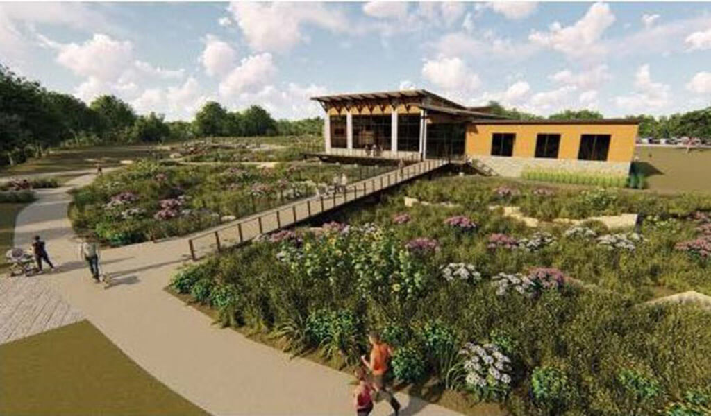
Rendering of the proposed Riverfront Conservation Education Center in Fort Dodge’s Central River District.
Wade kept talking about the planning pieces that we do a ton of collaboration. It is between the City of Fort Dodge, the Growth Alliance, Webster County, Webster County Conservation, and IDNR. This is the site of what we call the Central River District. Webster County is in the process of building its conservation center. We have meetings every two weeks, and we have all of those people on the phone or in a Team’s meeting or in person every two weeks working on this project. So, it is really cool the collaboration that we have and the interest that we have from so many different parties to be a part of this. You can see the rendering there on the top, and then you can see the construction. This is probably a picture from a week ago with the steel starting to go up on the conservation center. This site is also part of Destination Iowa. So, we were awarded a grant as a part of that last year.
This is just one component of that destination. Iowa is the conservation center. Again, it is just a cool collaboration between the city and Webster County Conservation to utilize our property to build this center to bring people down. We want this to be the hub for all the recreation in Webster County, whether it is our bike trails or the state’s largest OHV Park or whatever it might be. We want this to be the hub for all that action.
Central River District North 1st Street (21:58)
As a part of that, we knew that we needed to fix the infrastructure down there. As Wade said, this was the location back in the eighties before the Hormel meat packing plants, and a couple of other plants, and all those jobs went away. Over time, demolition had been done, but they did not do any subsurface excavation. So every time we started to work on this project with a street project or the nature center, we hit the concrete. You can see the street project here, we needed to put in the sanitary sewer, new storm sewer detention for stormwater management, and all of that, and you can see the construction going on. This street project is also part of our nature trail, so we will have a 10-foot side path adjacent to that. You see the parking being built for the nature center. So again, it is just a big collaborative project to redo this site.
Central River District Front Porch & In-Stream (22:44)
And then this is our portion of it. So again, on the Central River District, Wade had pointed out Central Avenue, which is right here. We are calling this our front porch. We are looking for some sort of covered structure, these are still just a concept at this point as to what we are going to build there, but we are looking for some sort of covered structure on some industrial-looking swings. It looks right out onto the riverfront. So, the river sits right here, and this is kind of the great lawn space, looking for more fishing jetties in that sort of space along here, maybe a little white water and activity a little further downstream. So just engaging the public, wanting to bring them to this site, get them engaged in the river and the Riverfront. Again, Destination Iowa helps us fund these projects.
Skatepark (23:25)
Another project just further downstream. So, if you are looking at the map, here is Central Avenue. Here is our Central River District, and here is the proposed skate park. Snyder & Associates was a part of the project in Des Moines to build the massive skate park there. We are not looking to maybe do something quite that big right now. We have a small little skate park that is completely underutilized. Nobody goes down there; the kids are not using it. Again, to revitalize it, to bring the action down to the riverfront, we are looking at this site. This is an 18-hole disc golf course right here. It used to be residential back in the seventies and the eighties, again with flooding issues and other things in that space. All those homes have been demolished and turned into a park. It used to be a nine-hole par three golf course, and now we have turned it into a disk golf course, and now we are going to look at adding the skate park. One of the other components of this is you can see the river splits right here in our Central River District. This is called Duck Island. One of the other components that we are looking at is how we can bring pedestrians, bicyclists, and that sort of thing out onto Duck Island and what we can do there with some primitive trails and that sort of thing. So, and just another little cool spot to bring folks down to the river.
Downtown Alleyway Improvements (24:33)
With all the development on the riverfront, we cannot forget about what connects to the riverfront and that is our downtown. The downtown needs improvement. So, with Main Street Fort Dodge, and our cooperation with them and looking at this alleyway improvements project, something that was part of our streetscape master plan a couple of years ago, we thought this was a little bit easier to implement versus wide-ranging, total redo of our streetscape downtown. Maybe we start with some smaller improvements, some get some energy going with our retailers in the downtown and show some positive impact to the residents. These are just some of the concepts that we are looking at with new lighting on each side, new alleys, trying to soften the streetscape up with some plantings, that sort of thing. Safety is a big concern. So, we have downtown camera systems, some other cool signage, and other things. It is just a way to clean up the back doors of some of these businesses and kind of create some energy then to move onto the major streetscape projects in the front.
Hydro Electric Park and In-Stream Features (25:32)
One of the last projects that we have not started yet, we are still looking for funding, and our city council has been great. One of the projects that is being looked at again is this hydroelectric space for what is left of it. You can see a little jetty sticking out here. This is in low flow. This was summertime last year. But looking at this space, this is what used to be the old powerhouse with little platform there. Playground, restrooms, and maybe another enclosed shelter potentially at this site. That is something that is in need in our community is enclosed. Shelters for graduation parties or anniversaries, birthdays, whatever it might be. So, looking at that, turning old tennis courts into pickleball courts is the new craze. Seeing a lot of that going on, converting those, and redoing those potentially. But again, we are just kind of cleaning up this space on this side, this is already a parking space, this is Loomis Park. We already have a trail system and parking and mountain bike access and all that on this side. So, it is cleaning up this side and working on improvements there. As I said, we are still looking for funding, and so this is a project that will probably be in the 2025-2027 type of timeframe.
With that, anything else to add, Wade?
Wade Greiman (26:40)
Just this one thing I would be remiss if I did not say, but you will see several different consultants involved in this process: RDG, ISG, Riverwise, and Shive-Hattery. We have had a great working relationship with all those folks. It has been fun to collaborate with the right people doing the right stuff for the city. So, I just wanted to mention that those guys are a very strong partner with these activities too.
Chad Schaeffer (27:03)
Yeah, it takes a whole village to do all these things. It is not just city staff, and it is not just Snyder. It is bringing together the right people who want a team to do all these types of projects.