Using Data to Improve Transportation Systems Functionality
As more and more people move to urban areas, the increasing strain placed on infrastructure and resources is a constant concern. To combat this problem, researchers and innovators developed the Smart City transportation system theory. In its simplest form, the Smart City concept uses new approaches, relationships, and technology (digital) to engage citizens better, deliver services, and enhance systems. The idea is to use continually collected data channels from multiple sources (people, vehicles, buildings, etc.) to assess patterns and inefficiencies. This information is then used to not only improve citizens’ lives but also minimize the environmental impact of the city itself.
The transportation engineering profession has an unmistakable role in Smart City implementation efforts. From creating free-flowing traffic corridors to improving neighborhood walkability, the engineering profession is at the leading edge of Smart City advancements.
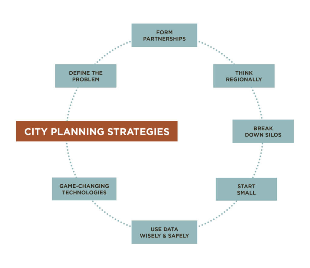
Seven-Step Strategy for Smart City Planning
Understanding the key strategies and focal points for effective Smart City planning is at the heart of a successful planning effort.
- Define the Problem – Defining the problem that needs to be solved upfront is essential to point the planning efforts in the proper direction. After identifying the problem, decide on the right technology and innovation that solves that problem. This avoids the unnecessary situation of putting new technology that doesn’t address the need. As you’ll read later, having a well-defined direction is essential for further planning efforts.
- Form Partnerships – Develop relationships with other people and organizations that have a vested interest in similar outcomes. These alliances multiply the number of backers available to advocate for your project. This can include community organizations, public health providers, schools, private citizens, and business leaders — the possibilities are extensive and may vary by project and location.
- Think Regionally – Almost as important as defining the problem upfront is to look at problems on a regional level, not just locally. Knowing the issues in adjacent towns, counties, and municipalities identifies commonalities that increase economies of scale. This may also open the door for partnership options.
- Break Down Silos – Another benefit of forming partnerships with other groups is the ability to break down silos — the “us vs. them” mentality. This helps everyone see and understand the shared vision and goals. A “Team of Champions” can be created for assigning cross-functional liaisons that drive project results.
- Start Small – Proof of concept and pilot projects can be beneficial at a small scale before scaling up. This avoids needlessly expending resources before success is a known outcome.
- Use Data Wisely & Safely – Data analytics is a crucial aspect of the decision-making process. Data is the beating heart of the Smart City, collecting information from multiple sources to improve living standards. The collection of massive amounts of data also facilitates the need to prioritize the security and safety of all data and communications.
- Game-Changing Technologies – Emerging technologies, like virtual reality (VR), provide unparalleled project insight. Visualization is critical for better community engagement and education. This technology allows users to “see” a completed project in a 3-dimensional environment before a shovel is turned.
Starting Small, Smart City Project Approach
Starting a project with modest goals is best explained by Traffic Group Leader Mark Pennington with Snyder & Associates. His work with numerous cities and Metropolitan Planning Organizations (MPOs) highlights how a Smart City project doesn’t need expansive goals to create an outsized impact.
Step it Up DSM was a multi-organizational effort to improve the walkability of three Des Moines area schools to meet the Surgeon General’s Call to Action, which promotes walkable communities. As Mr. Perington states, “…none of the projects alone were complicated or expensive, but the impact will create a much better walking environment for students in the neighborhood.”
The project started with small groups performing walk audits in the target area. The groups identified sidewalks that were missing or needed repairs and crosswalks that were not fully accessible. They also looked at public transit stops and the need for fill-in concrete in some locations to make them more accessible for students. Small initiatives of this type can be instrumental in leading to even larger Smart City projects.
Smart City Planning Technology Awareness
The role of Transportation Engineers in implementing Smart City amenities is evident from a technology perspective. A wide range of reporting devices, such as sensors, visibility devices, and other endpoints, create the data that makes a Smart City work. And many of these transportation system technologies are not necessarily new. Many have been around for years. The problem is that city and community leaders are not aware of them. Some of the more common system technologies include;
- Traffic Incident Management
- Emergency Vehicle Pre-emption/ Transit Signal Priority
- Leading Pedestrian Intervals
- Adaptive/ Responsive Traffic Signals
- INRIX/ Streetlight Data
- Transportation & network operations centers
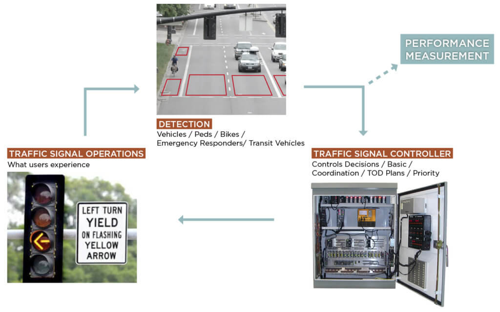
Automated Traffic Signal Performance Measures (ATSPM)
ATSPMs are another highly beneficial tool for moving into the Smart City world. ATSPMs modernize traffic signal management by utilizing high-resolution data in real-time. This allows traffic engineers to change signal timings based on actual performance rather than software modeling or manually collected data. Deficiencies can be identified and corrected before problems occur. This technology is cost-effective and can be applied to a wide range of signalized intersections — often using existing infrastructure in many cases.
Transportation Planning Using Observation Cameras
As the on-call traffic engineering firm for the City of Waukee, Snyder & Associates has moved the community further along the Smart City path with new technology that provides a new way of observing traffic, according to Mr. Perington. “After years of making physical changes to the Highway 6 corridor to account for the rapid growth in the area, the recent addition of a city-wide observation camera system takes advantage of digital capabilities. The observation cameras allow the traffic engineers at Snyder & Associates to view the corridor areas remotely in real-time.”
This level of service means less time traveling to the site to conduct traffic observations. Instead, engineers have access to live feeds of the corridor, allowing improvement decisions to be made quickly. Soon, engineers look to implement ATSPMs that will enable remote changes to traffic signal timing through access to the city’s central management software.
DSM MPO Smart City Approach to Transportation Planning
Another prime example of Smart City planning in action is the Smart City Roundtable. A couple of years ago, the Des Moines Area MPO and Capital Crossroads joined forces to create the roundtable. Capital Crossroads is a consortium of community organizations in central Iowa that already uses a regional approach to build awareness around community planning. The goal of the Smart City Roundtable is to explore how technology can be used to enhance urban systems and, ultimately, address community challenges.
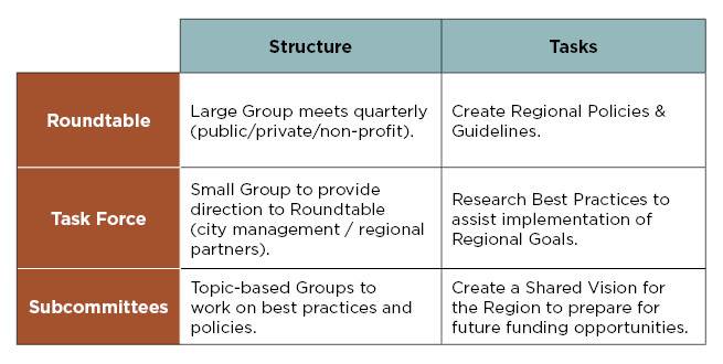
The Smart City Roundtable is organized around large, quarterly group meetings with multiple community and organization representatives. A small task force meets regularly to provide direction, while individual subcommittees focus on best practices and policies.
True to Smart City planning principles, the roundtable starts by defining the problems and challenge areas that must be addressed. In the transportation realm, this means determining which system optimization projects are priorities and how technology and innovation can be used to support regional and community transportation goals.
Individual projects can be identified once the group’s goals and vision are defined. These projects were established to align with the MPO’s 2050 Long-Range Transportation Plan (LRTP). Examples of potential projects include:
- Traffic operations of arterials/ collectors
- Expanding mobility sharing options (i.e., bike and scooter sharing)
- Electric fleets/ charging station infrastructure
- CV (connected vehicles)/AV (automated vehicles) infrastructure (i.e., smart parking)
After the project structure is established, the following steps include identifying champions from communities in the region who are best able to move the projects forward. A framework for implementing a regional Intelligent (Smart) Transportation System (ITS) is also designed, and an MPO-led ITS regional inventory is completed. In a very short time, the Smart City Roundtable has emerged as a model organization for any region looking to improve efficiencies using Smart City principles.
The Future of City Planning is Smart
To address the ever-increasing migration of people from rural to urban areas, communities of all sizes must embrace Smart City principles to confront the growing pressure on infrastructure and limited resources. Moving people around our cities efficiently and safely will increasingly fall on the transportation engineering profession as this relocation continues. Using “smart” solutions to prepare for this movement is essential for maintaining a thriving society.


