2727 SW Snyder Blvd, Ankeny, IA 50023

1 (888) 964-2020


Navigation

Water Access Upgrade Expands Amenities at Hubbard Park: Shorewood, Wisconsin

The strategic design ensures that user safety and access are top priorities.

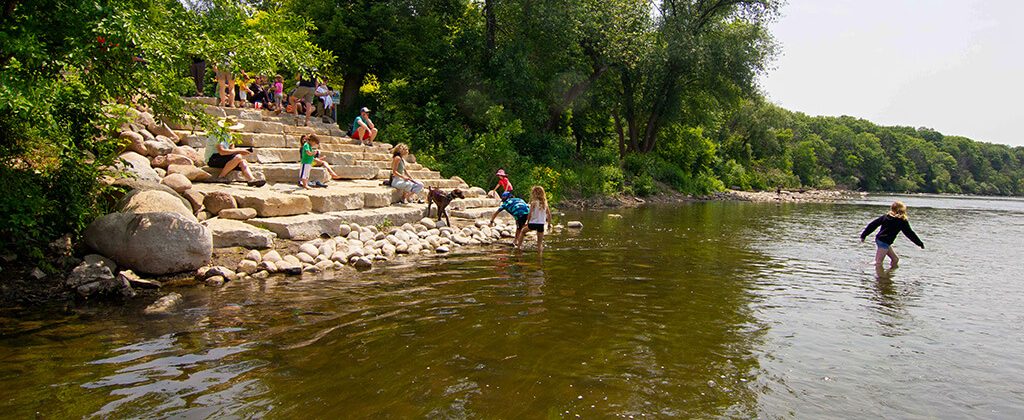
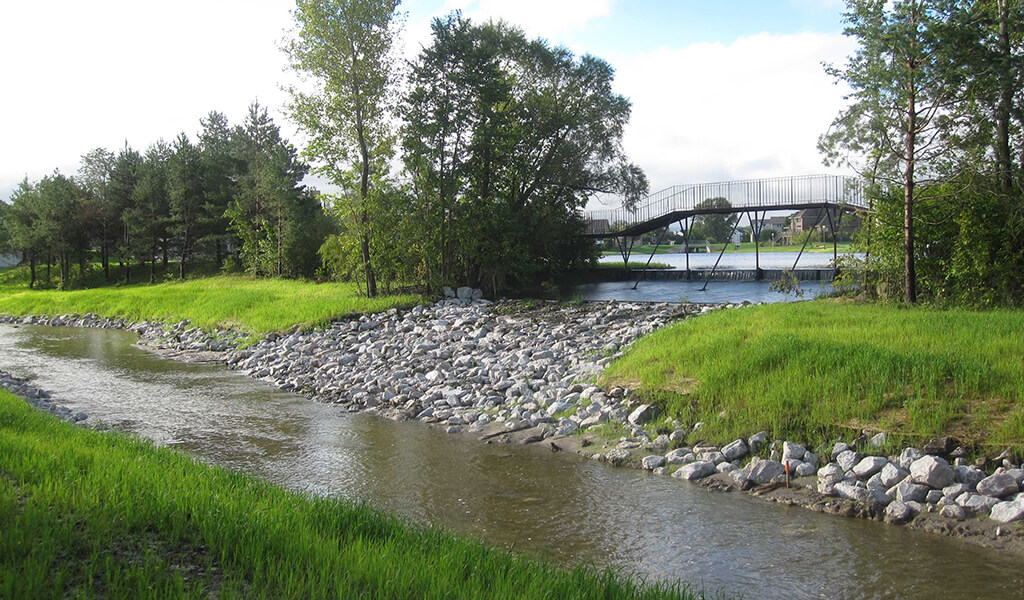
Hubbard Park in the Village of Shorewood is a local landmark in this Wisconsin community. Located on a nearly five-acre, 1,400-foot-long strip of land between the Milwaukee River and the former Chicago and Northwestern Railroad, the park contains the Hubbard Park Lodge and access to the Oak Leaf Trail. However, despite its location along the river, the park lacked easy access to the water’s edge for recreational watercraft. The Shorewood Public Works Department enlisted the services of the Snyder & Associates design team to develop a plan for a canoe and kayak launch that would give users of the park greater access to the Milwaukee River.

Charged with creating a launch that would aesthetically fit with the existing park site, our team worked closely with local river groups, the Wisconsin DNR, and the Public Works leadership to balance the goals of the project and the overall project budget. It was agreed by all stakeholders the canoe and kayak launch had to be highly functional for various river levels, extremely durable for longevity, and easily accessible from a nearby parking area.

Material Challenges Test the Design Team

The design team faced numerous challenges, including matching the high-quality amenities in the park on a limited project budget. This meant the team also needed to source materials that were logistically close to the park to reduce delivery expenses and help keep the overall environmental impact to a minimum. The primary challenge, however, required finding materials that would withstand the river’s elements and Wisconsin’s frigid winters.

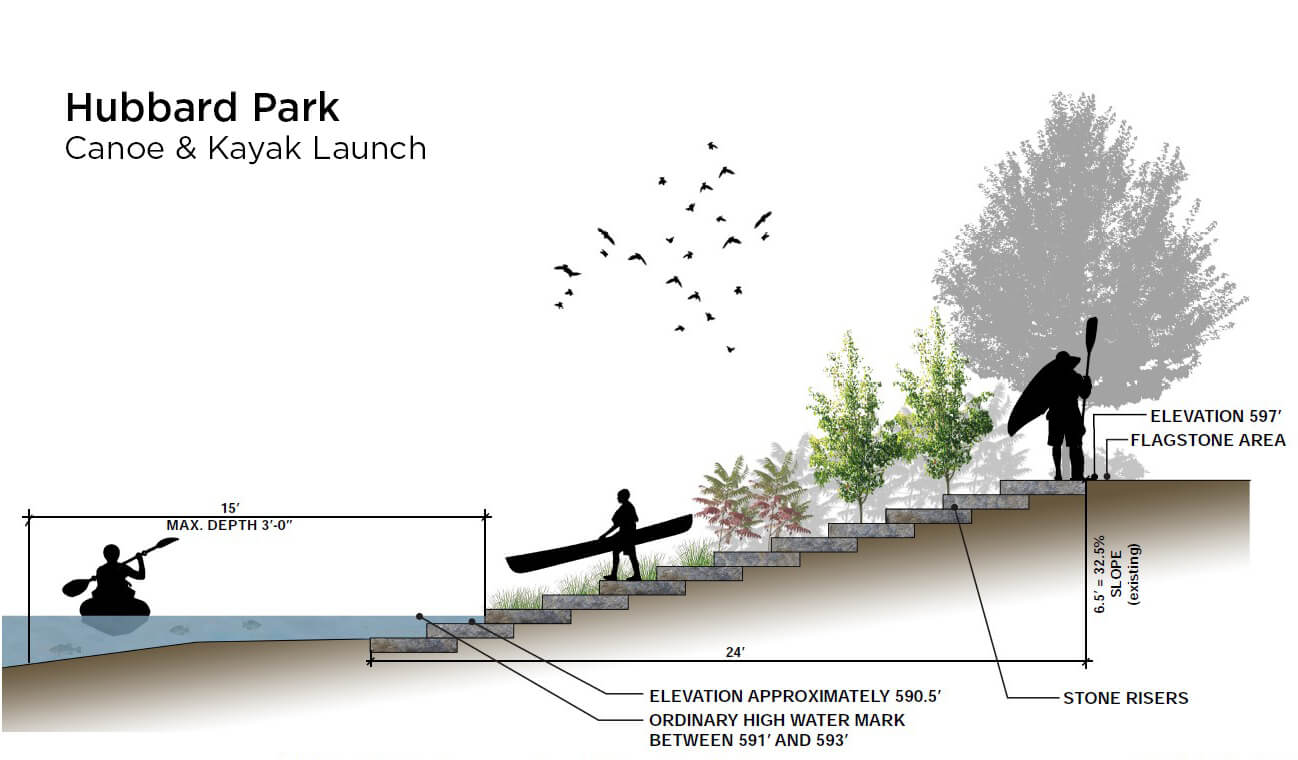
Our team’s solution called for snapped, 6″ Eden riser stones that provided a “zero-entry” area for the easy and safe launch of canoes and kayaks. Also, high-quality Eden outcropping stones were arranged to create a natural “amphitheater” area where users could comfortably sit and view the river. By sourcing local products, our team created a locally relevant, structurally timeless amenity and reduced the cost of transit to get the materials onsite.

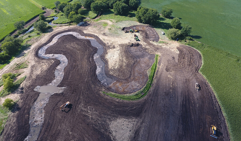
Following a graded path near the end of N. Morris Blvd. in Hubbard Park, the project area required approximately 35 cubic yards of earthwork grading, the installation of roughly 70 tons of outcrop stones and boulders, and the placement of approximately 16 pieces of snapped stone. With the canoe and kayak launch substantially completed, park users and recreational river enthusiasts now have a more convenient way to access the river that’s safe, aesthetically pleasing, and constructed with durability that will last for generations.

Client

Village of Shorewood

Client Type

Project Type

Andrew Meessmann, PLA

Andrew Meessmann, PLA

Landscape Architect

Related Projects

exposed siphon at omaha papio creek|drone map of the Papio Creek in Omaha NE|papio creek stream

Safeguarding Critical Infrastructure and Water Resources: Omaha’s “Papio” Creek

In March 2019, the City of Omaha faced a significant threat to its critical infrastructure under West Papillion Creek (known to locals as Papio Creek). A disastrous...
||Restoration from Marsh to Top Tier Course with featuring bright green golf course and Trees in background|

TPC Wisconsin Emerges as a Premier Golf Course

In the heart of Madison, Wisconsin, a remarkable transformation has occurred, reshaping the golfing experience for enthusiasts and professionals alike. Dennis Tiziani,...
South Dakotas capitol building behind dredging equipment on lake|excavator on floating platform|excavator dredging from shoreline|sediment being pulled from lake bed|aerial view of capitol lake in south dakota|Dump truck being filled with sediment from of South Dakota's Capitol Lake

Sediment Buildup Necessitates Lake Dredging Project at South Dakota Capitol Complex

2023 Build South Dakota Awards, Category II AGC Award One of the prominent features complementing the architectural beauty of the Capitol Complex in Pierre, South...
Aerial view of construction at Niebuhr Mitigation bank|update stream with new protections|aerial view of niebuhr mitigation bank|field of reed canary grass|construction machinery creating low water crossing in a stream|snyder & associates employees walking through mitigation bank|construction machinery digging out dirt for stream

Niebuhr Stream Mitigation Bank Establishment & Environmental Benefits

The Niebuhr family farm in Northeast Iowa contains a perennial stream called Buck Creek, bordered by fields that were historically used for cattle pasture. Over time,...
A winding trail moves towards the Wanatee bridge|Wanatee pond project|Wanatee pond project|Wanatee bridge sits over a stream of water surrounded by native plantings|Wanatee pond project|Civil Engineer Lindsay Beaman and and Environmental scientist Nichoel Church receive ACEC award 2022|new steel bridge over wanatee creek|Pedestrian bridge in Wanatee Creek on a fall day|green

Wanatee Park Upgrades Improve Wetlands & Recreational Opportunities

American Council of Engineering Companies (ACEC) of Iowa Grand Place Award in 2022 in the Special Projects Category In November 2016, Linn County Iowa residents passed...
|Kwik Star Convenience Stores Continued Growth||Stormwater drain

Kwik Star Convenience Stores Continued Growth

Fresh meals and competitively priced grocery items aren’t what most of us expect when we visit a convenience store. Kwik Star, however, is setting the bar higher with...
bridge over Fourmile creeks|Butterfly on a flower bush|Stream across Iowa|Fourmile Creek Iowa||||rainstorm Fourmile Creek|Fourmile creek construction

Fourmile Creek Watershed Stabilization and Water Quality Improvements

The Fourmile Creek Watershed in central Iowa consists of nearly 80,000 acres of urban and agricultural communities. It’s also home to over 80,000 residents. As this...
overlooking green wetland area with meandering stream|Fourmile wetland during construction||Wetland stream meanders|Fourmile creek map

Manmade Stormwater Wetland Benefits Fourmile Creek Water Quality

Across the country, effective stormwater management is vital for building urban resiliency and meeting stringent water quality standards. To fulfill this objective,...
|||aerial view of noelridge park||broken down double culvert on narrow stream||

Noelridge Park Stream Mitigation Improves Park’s Biological Health

Restoration & Stabilization Required to Combat Stream Erosion Conveniently located on the north side of Cedar Rapids, Noelridge Park is a 100-acre community park...
wetland during the fall season with a small pond|||green fields with small pond under blue sky|monarch butterfly on grass in wetland mitigation site|looking down a tree tube at young tree sprout|shovel holding soils during a wetland site visit|looking down the newly paved cedar valley nature trail|construction of new bridge

Cedar Valley Nature Trail Benefits from Wetland Mitigation

Environmental Services Expedite Trail Restoration The Cedar Valley Nature Trail traverses nearly 52 miles from Evansdale to Hiawatha, crossing the Cedar River at...

more than 45 years

Serving Clients Around the Country

DB+