Transportation Planning Provides Clear & Effective Strategy for Improvements
As public demand for bicycle and pedestrian infrastructure and improved community connectivity grows, transportation master plans are becoming increasingly popular in communities of all sizes. Using a data-driven approach, transportation master plans provide actionable steps for achieving multi-modal goals that enhance community livability.
Mark Perington, P.E., PTOE, and Traffic Group Leader for Snyder & Associates, explains, “Communities often have a comprehensive plan that includes multi-modal transportation system goals to support the safe and efficient movement of people and goods.
However, they often lack the details on how to bring those goals to life. That’s where a transportation master plan comes into play. They go beyond a comprehensive plan and provide clarity and direction a community can use and act upon, making them very useful.”
Because no two locations are exactly alike, transportation master plans vary in scope and detail and are customized to address each community’s needs. The primary goal of a plan is to help prioritize specific projects or improvement areas and identify funding sources to streamline their construction and maintenance needs.
Documenting Current Transportation System Conditions through Data Collection
Although customized for individual communities, all transportation master plans follow similar steps that guide the process forward. The first step is to formally document how your current transportation system works. With a primary focus on the safety and capacity of roadways, sidewalks, and bicycle facilities, data collected at this stage often includes:
- Crash Data — Available from a state’s Department of Transportation (DOT) or local police department, crash data helps identify crash hot spots, trends in crash types, and causes of injury-related crashes.
- Traffic Congestion — Regional travel demand models help determine areas where additional lanes might be needed and opportunities to reduce the number of lanes to accommodate multi-modal transportation.
- Existing Transportation Network — Existing maps of a current network depicting routes for trucks, emergency response vehicles, public transit, sidewalks, and bike facilities.
- Land Use — Existing and future land use maps provide context about a transportation network and how land use affects roadway corridors. Current or planned significant traffic-generating developments can impact a transportation system on a regular or seasonal/periodic basis.
- Public Health/Equity — Metropolitan or regional planning commissions and local public health officials can provide geographic location information, transportation system performance metrics, and predominant health concern data that impacts traditionally underserved populations.
- Community Input — Local government departments (i.e., public works, parks and recreation, police, and fire departments) and public engagement efforts can provide important information that doesn’t appear in other data.
Identifying Transportation System Improvements
Combining this newly gathered data with a community’s transportation goals creates a vision for the ideal transportation system. The next step is to compare this
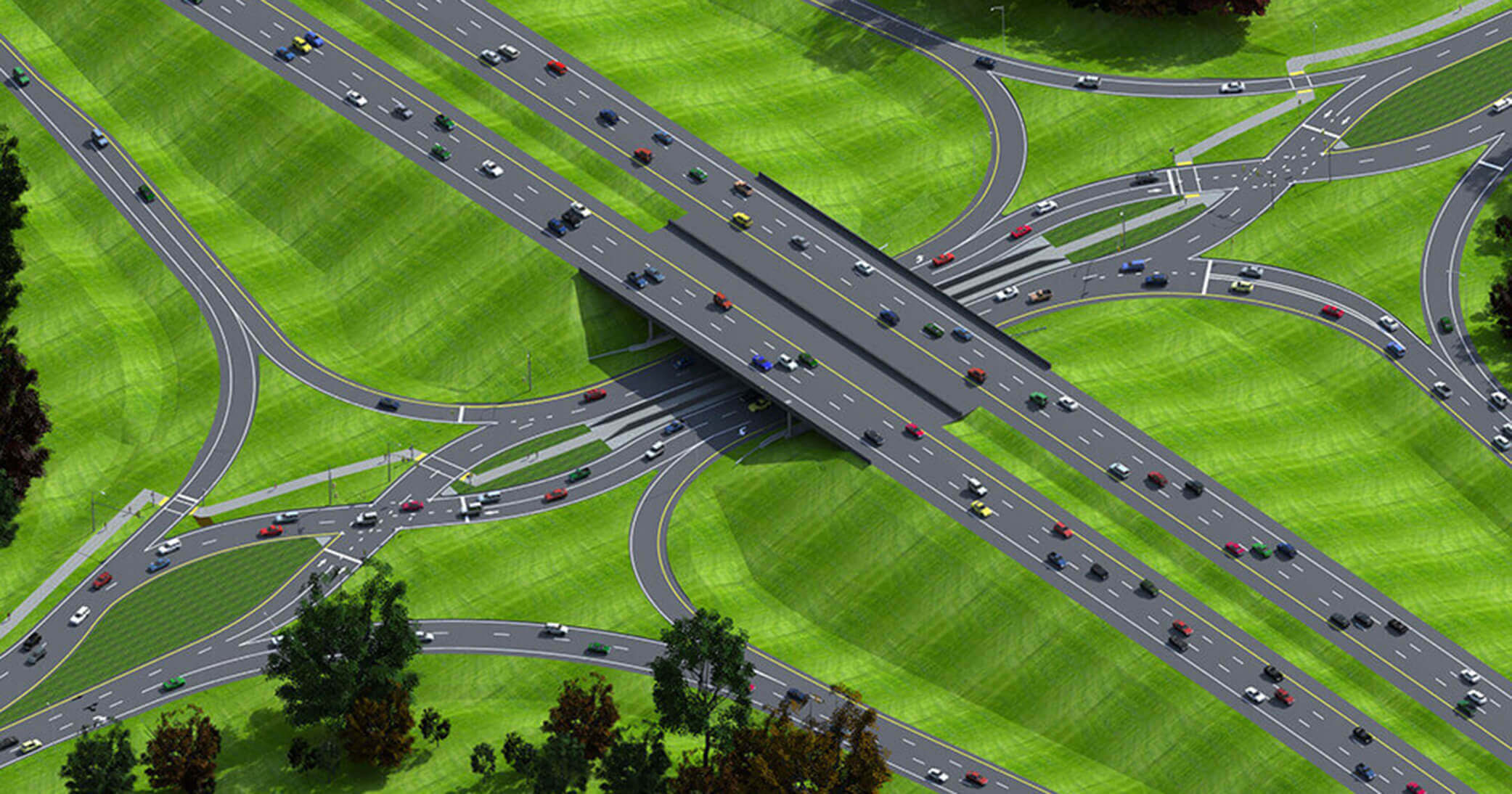
A diverging diamond interchange is a safer alternative to traditional interstate interchanges.
vision with the current state of the transportation system to identify gaps that should be addressed. These gaps become actionable improvements in these traffic subsets:
- Traffic Capacity — Streets, sidewalks, and bicycle facilities that exceed capacity and are projected for additional growth may need to be widened. This may also present opportunities for lane reductions, resulting in more space for bicycle and pedestrian traffic or parking.
- Intersection Improvements — Safety and capacity concerns can be eased with traditional traffic controls such as stop or yield signs and traffic signals. Access management techniques, such as limiting certain movements or combining access points, can also lead to improvements. Other innovative solutions, such as roundabouts and diverging diamond interchanges, are designed to address specific intersection issues.
- Multi-modal Networks — Safe and efficient accommodations for alternative modes of travel are a primary focus for many U.S. communities. Dedicated pedestrian and bicycle networks reduce our dependence on motorized travel and make connecting with parks, athletic facilities, and other destinations easier through active transportation.
- Large Vehicle Routes — Primary routes used by emergency vehicles, public transit, and semi-trucks often feature specific accommodations to keep users moving efficiently. These routes are designed for large cars and provide adequate intersection turning radii and lane widths. They may also include emergency vehicle preemption or transit signal priority at traffic signals.
Prioritizing Transportation System Improvements
Once the desired transportation improvements have been identified, the next part of the process is prioritizing project construction efforts using a combined data-driven approach, including crash review and cost/benefit analysis.
Other inputs that should be considered include aligning improvements with efforts such as pavement management plans and upcoming utility projects. Other construction projects that impact an area (including private development) would also fall into this category.
An example of this approach would be prioritizing active transportation improvements near a school or underserved neighborhood. Ultimately, this exercise results in a prioritized implementation program that addresses critical issues while remaining mindful of other community planning efforts.
Funding Transportation Improvements & Ongoing Maintenance
With a prioritized implementation plan established, the natural progression is to figure out how to fund improvement projects and maintenance efforts for your transportation system. “When it comes to funding, it’s crucial to think about both the cost of initial improvements and ongoing maintenance,” shares Perington. “One of the most eye-opening things I have learned from my friends in the public sector is the impact of new projects on operating and maintenance budgets. If those costs aren’t addressed upfront, the long-term success of a project can be jeopardized.”
Due to the significant costs usually associated with transportation system improvements, Perington advises incorporating projects identified through the master plan with a community’s Capital Improvement Plan. “Having a transportation master plan developed by the community, backed with data, and incorporated into a Capital Improvement Plan, helps to keep future projects on track as time goes on and political interests or staff changes.”
Outside sources can be sought through state and federal agencies to supplement local project funding. A well-established transportation master plan provides the supporting documentation to enhance your chances of securing outside funding. “A transportation master plan shows that projects have been developed to directly improve safety and provide high value to the community, which is important when applying for grants and other sources of supplemental funding,” shares Perington. The key to success is to align the goals and outcomes of identified improvements with those of the funding programs.
Measure Progress to Increase Impact of Transportation Master Plan
Like other community planning efforts, a transportation master plan should be treated as a living document through regular updates or amendments. The timing will be different for every community. Still, an excellent time to revisit the plan can be during capital improvement planning, strategic planning, or when new traffic projections become available.
Between updates, it’s a good idea to track the progress of plan accomplishments. Performance measures can be developed based on the goals and priorities identified in the plan. These measures can include improved crash rates, an increased number of multi-modal projects, traffic congestion reduction, or the percentage of new projects being constructed in underserved neighborhoods and areas.
Transportation master plans turn multi-modal goals into data-driven implementation programs that make traveling easier and safer as a pedestrian, bicyclist, transit user, or motorist. While the process may seem overwhelming to some community leaders, Perington carefully points out that there’s nothing to fear. “Developing a transportation master plan isn’t as daunting as it seems. It’s an exercise of collecting and organizing various forms of data. You listen to what your community wants and needs, and then prioritize improvements for safety and efficiency while aligning with other improvement activities already underway.”